
La vera "route 1", la strada ad anello che permette di visitare gran parte dell'Islanda, comincia oggi. E lo fa con il botto, ovvero offrendo il tratto con probabilmente più bellezze in assoluto, un continuo susseguirsi di cascate, percorsi da trekking ed infinite scogliere dalle quali ammirare (se il periodo dell'anno è quello giusto), anche i mitici puffin. La magia comincia pochi km ad est di Reykjavik, quando la "ring road" prende il via ufficialmente e vi condurrà, se state percorrendo il giro in senso antiorario, ad attraversare la carinissima Selfoss e poi la piccola Hella prima di effettuare la deviazione che porta al primo stop di giornata...
The real "route 1", the ring road that allows you to visit a large part of Iceland, begins today, by offering the stretch which is probably the most beautiful of the entire route, a continuous succession of waterfalls, hiking trails and endless cliffs from which to admire even the legendary puffins. The magic begins a few kilometers east of Reykjavik, when the "ring road" officially starts and then leads you, if you are traveling counterclockwise, to the cute town of Selfoss and then to the small Hella before making the first detour of the day. The one that leads to the first stop of this amazing day 5...

A sud della città, infatti, una svolta sulla sinistra lungo la "264", che ad un certo punto diventa sterrata, conduce alle Keldur Turf House. E' il nostro primo vero approccio con le tipiche case in erba islandesi. Il villaggio è suggestivo (ingresso gratuito, è possibile visitarle nelle ore centrali della giornata), ti aspetti da un momento all'altro che possano uscire gli elfi per salutarti... Questa fattoria è decisamente ben tenuta e rende l'idea di come potesse essere la vita all'epoca in cui queste case erano attive. Il primo insediamento, infatti, risale all'anno mille.
To the south of the city, in fact, a turn to the left along the "264", which at a certain point becomes a dirt road, leads to the Keldur Turf Houses. This is our first real approach to the typical Icelandic turf houses. The village is charming (free entrance, you can visit them in the middle hours of the day), you expect from one moment to the next that the elves may come out to greet you ... This farm is definitely well maintained and gives you an idea of what life might have been like at the time when these houses were active. In fact, the first settlement dates back to the year 1000.


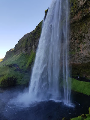
SELJANDFOSS E GLJUFRABUI, IN POCHI METRI DUE SPLENDIDE CASCATE
Eravamo a conoscenza del fatto che la "ring road" offrisse bellezze naturali ad ogni angolo, ma non avevamo davvero idea che potessero essere così affascinanti. Ed invece, dopo neppure 100 km, abbiamo immediatamente dovuto ricrederci, non appena in lontananza ci sono apparse le cascate Seljalandfoss e Gljufrabui, distanti l'una dall'altra circa 300 metri e collegate da un brevissimo sentiero.
SELJANDFOSS AND GLJUFRABUI, TWO AMAZING WATERFALLS
We were aware of the fact that the "ring road" was able to offer natural beauties at every corner, but we really had no idea that they could be so fascinating. As soon as we left Reykjavik (after 100 km) we had to change our mind. Seljalandfoss and Gljufrabui waterfalls are just amazing and are located one next to the other.

E se le Seljalandfoss le troverete in qualunque cartolina islandese, lo stesso discorso non vale per le vicine Gljufrabui, alta 40 metri (131 piedi) e nascosta in una fenditura della scogliera. A causa del suo efficace "nascondiglio", Gljúfrabúi è, infatti, spesso trascurata dalla maggior parte dei viaggiatori.
Well, while you'll find Seljalandfoss on any Icelandic postcard, the same cannot be said about the nearby Gljufrabui, 40 meters (131 feet) high and hidden in a cleft in the cliff. Because of its effective "hiding place," Gljúfrabúi is, in fact, often overlooked by most travelers.

Ma la grande attrazione è soprattutto lei, Seljalandsfoss, la "cascata liquida", uno dei simboli dell'Islanda. Alta 65 metri, è speciale perchè unica cascata (almeno tra quelle raggiungibili lungo la la ring road) è che si può ammirare da diverse angolazioni, grazie al sentiero che passa proprio dietro la cascata stessa, garantendo al visitatore la possibilità di effettuare foto davvero stupende.
But the main attraction is above all the Seljalandsfoss, the "liquid waterfall", one of the symbols of Iceland. It's sixty-five meters high and very special because it's the only waterfall (at least among those reachable along the ring road) that can be admired from different angles, thanks to the path that goes right behind the waterfall, giving visitors the opportunity to take really great photos.

Occorre prestare un pizzico d'attenzione quando affronterete il sentiero (sempre bagnato) che circonda le cascate, ma ne varrà davvero la pena raggiungere la parte dietro, per ammirare il fiume Seljalandsá, il Fiume Liquido, che cade per circa 60 m da quella che in altri tempi era una scogliera sull'oceano (ora distante parecchi chilometri) e che oggi è il confine tra le Highlands e le Lowlands.
It is necessary to be careful when facing the path (it's always wet and muddy) that surrounds the falls, but it you get to the back of the falls, you can admire the Seljalandsá River, the Liquid River, which falls for about 60 m from what in the past was a cliff on the ocean which is nowadays far from the falls. Now it marks the border between the Highlands and the Lowlands.
IL PARADISO? LE SKOGAFOSS E FIMMVORDUHALS TRAIL
No, non stiamo esagerando. Non c'è luogo in Islanda che possa regalarvi come aperitivo una delle cascate più belle d'Europa e poi, altre 26 più o meno piccole cascate lungo uno dei sentieri più affascinanti del paese, capace in 25 km di regalarvi di tutto, dalle cascate ai canyon, dai paesaggi lunari ai ghiacciai. Originata dal fiume Skógaá, la Skogafoss contende alle Gullfoss (la cascata d'oro) il titolo di cascata più fotogenica d'Islanda anche per l'incredibile facilità con cui il sole, colpendo le gocce d'acqua sollevate dalla caduta, dà origine a splendidi arcobaleni. In una giornata soleggiata, come è accaduto a noi, l'arcobaleno sarà davvero impressionante...
THE PARADISE? SKOGAFOSS AND FIMMVORDUHALS TRAIL
No, we are not exaggerating. There is no place in Iceland that can give you one of the most beautiful waterfalls in Europe and then, another 26 small waterfalls along one of the most fascinating trails in the country. It is 25 km long and gives you everything, from waterfalls to canyons, from lunar landscapes to glaciers. Originating from the river Skógaá, the Skogafoss rivals Gullfoss (the golden waterfall) for being he most photogenic waterfall of Iceland. It's just amazing, especially in a sunny day, when the sun, hits the drops of water raised by the fall, and creates beautiful rainbows. On a sunny day, as happened to us, the rainbow is just really impressive ...

Secondo la leggenda islandese, il primo vichingo ad essersi stabilito nella zona nascose un tesoro, un forziere di monete d'oro, nella caverna dietro la cascata. Sono stati in molti ad essere corsi sin qui per cercare questo tesoro, finchè un ragazzo riuscì nell'impresa di scovarlo. Attaccò una corda ad uno degli anelli laterali, iniziò a tirare, ma l'anello si ruppe e il forziere affondò. In ogni caso, ancora oggi si dice che chiunque si bagni nelle sue acque possa ritrovare un oggetto perduto e a lungo cercato.
According to Icelandic legend, the first Viking to settle in the area hid a treasure, a chest of gold coins, in the cave behind the waterfall. Many people rushed here to look for this treasure, until one boy took on himself to find it. He attached a rope to one of the side rings, he then pulled but the ring broke and the chest sank. In any case, even today it is said that anyone who bathes in its waters can find a lost object...

Se le Skogafoss non sono abbastanza, dietro al museo parte un sentiero di venti minuti circa che conduce ad un'altra splendida cascata, Kvernufoss, alta ben 30 metri. Se siete alla ricerca di uno spot solitario ma ugualmente affascinante, questa cascata fa al caso vostro.
If the Skogafoss falls are not enough, just behind the museum there's a path of about twenty minutes that leads to another beautiful waterfall, Kvernufoss, which is 30 meters high. If you're looking for a lonely but equally fascinating spot, this waterfall is for you.

TUTTO QUELLO CHE C'E' DA SAPERE SUL FIMMVORDUHALS TRAIL
A destra della cascata si inerpica una scalinata di circa 700 gradini che porta al culmine della cascata stessa e segna di fatto l'inizio di uno dei percorsi da trekking più belli ed affascinanti d'Islanda, il Fimmvorduhals trail. E' un sentiero di 25 km "point to point", ciò significa che dovrete prevedere (nel caso in cui vogliate completarlo integralmente) di concludere la fatica a Thórsmörk (dal nome del dio nordico Thor). La verità è che anche un "one day hike", che vi permetta di tornare sui vostri passi quando sarete stanchi non sarà affatto deludente.
EVERYTHING YOU NEED TO KNOW ABOUT THE FIMMVORDUHALS TRAIL
To the right of the Skogafoss there is a staircase of about 700 steps that leads to the top of the waterfall and marks the beginning of one of the most beautiful and fascinating trekking trails in Iceland, the Fimmvorduhals trail. It is a 25 km "point to point" trail, which means that you will have to plan (in case you want to complete it) to end the effort in the small town of Thórsmörk. The truth is that even a "one day hike" that allows you to retrace your steps when you are tired isn't disappointing at all.

Ed è poi quello che abbiamo fatto noi, ovvero percorso buona parte del primo tratto di un trail che si divide in tre distinte aree:
1) dal Fiume Skógá al rifugio Fimmvörðuháls
2) Passaggio tra i ghiacciai Eyjafjallajökull e Mýrdalsjökull
3) Goðaland, l'area che scende verso Thórsmörk
And that's what we did. we walked most of the first part of a trail that is divided into three distinct areas:
1) From the Skógá River to the Fimmvörðuháls hut.
2) Passage between Eyjafjallajökull and Mýrdalsjökull glaciers
3) Goðaland, the area that descends towards Thórsmörk

La prima area è sicuramente la più famosa ed è di fatto quella più percorsa dai turisti. Dalle Skogafoss si salgono numerosi gradini e si prosegue lungo gli 8 km iniziali (dei 25 totali) del sentiero delle cascate. Si chiama così perchè lungo il percorso, che costeggia il fiume Skògaà, se ne incontrano ben 26 di cascate ed il numero non è neppure certo visto che sono in tanti quelli che dicono di averne viste anche di più. Se voleste percorrere per intero la prima parte del trail, ovvero fino al rifugio Fimmvorduhals, i km saranno 16 (8 + 8). Il trail è molto ben segnalato ed è di fatto impossibile perdersi perchè ci sarà sempre il fiume a farvi compagnia. Per i primi 5 km troverete anche tantissimi hikers a farvi compagnia, ma più in là andrete più vi ritroverete da soli...
The first area is surely the most famous and it is in fact the one most traveled by tourists. From Skogafoss you'll have to climb the many steps and continue along the first 8 kilometers (of the 25) of the waterfalls path. It is so called because along the trail, which runs along the river Skogaà, you'll see at least 26 waterfalls and the number is not even certain since there are many who say they have seen even more falls!. If you would like to cover the entire first part of the trail, that is up to the Fimmvorduhals refuge, the lenght is 16 km (8 + 8). The trail is very well marked and it is actually impossible to get lost because there will always be the river to keep you company. For the first 5 km there are also many hikers on the trail, but the further you go the more you will find yourself alone...


A un terzo del percorso, attraverserai il fiume Skógá su uno stretto ponte ed entrerai in una regione vulcanica tra due ghiacciai (la seconda parte del trail). Lo scenario subisce un netto cambiamento, si passa da un lussureggiante canyon a rocce vulcaniche. Il sentiero sale dolcemente per alcuni chilometri fino a raggiungere il rifugio. Il terzo ed ultimo tratto, dopo aver superato il ghiacciaio, sarà una lenta ma costante discesa verso Thórsmörk.
One-third of the way through, you'll cross the Skógá River on a narrow bridge and then enter the volcanic region between two glaciers (the second part of the trail). The scenery undergoes a distinct change: from a lush canyon to volcanic rocks. The trail climbs gently for a few kilometers until you reach the refuge. The third and last stretch, after passing the glacier, will be a slow but steady descent towards Thórsmörk.


I primi stop potrebbero valere già la giornata tanto sono incredibili, ma Vik è ancora distante 35 km e, come imparerete presto in Islanda, ed in particolare lungo la "route 1", le bellezze sono davvero dietro l'angolo. E allora non ci si può accontentare e, poco prima di arrivare a Vik, svoltiamo a destra lungo la "218" in direzione promontorio di Dyrhólaey, un'incredibile porta d’accesso all’oceano generata da due troll trasformati in pietra. Si viene qui per tanti motivi, ma noi ci siamo spinti fino al mare per ammirare soprattutto loro, i puffin, le pulcinella di mare, uno dei grandi simboli dell'Islanda. Ce ne sono tantissimi e rimarranno qui fino alla fine di agosto.
DYRHOLAEY AND REYNISFJARA, BETWEEN PUFFINS AND BLACK BEACHES...
You might call it a day afther the first stops: they are so incredible, but Vik is still 35 km away and, as you will soon learn in Iceland, and in particular along the "route 1", the beauties are really around the corner. This is why we can't still be satisfied and, just before arriving in Vik, we turn right along the "218" in the direction of the Dyrhólaey promontory, an incredible gateway to the ocean created by two trolls transformed into stone. People come here for many reasons, but we are going as far as the sea to admire the puffins, one of the great symbols of Iceland. They're going to stay there till the end of august...


© RIPRODUZIONE RISERVATA
© COPYRIGHT - ALL RIGHTS RESERVED
FOLLOW US ON FACEBOOK: WWW.FACEBOOK.COM/DUECUORIPERVIAGGIARE?REF=HL
Nessun commento:
Posta un commento