Visualizzazione post con etichetta PHOENIX AND TUCSON: 10 DAYS IN THE LAND OF... CACTUS. Mostra tutti i post

venerdì 8 aprile 2022

The best of Phoenix and Tucson: 10 days exploring the "land of cactus" (Day 1 - Phoenix: McDowell Sonoran Preserve)

C'è un luogo magico, tra i tanti che caratterizzano gli splendidi Stati Uniti, che da sempre fa sognare i viaggiatori di tutto il mondo. E' l'Arizona del Grand Canyon e degli altri grandi canyons, delle culture native che popolano questo arido territorio da moltissimo tempo, ma anche del deserto e delle temperature semi-impossibili estive, dei cactus e della profonda influenza di quel Messico che è davvero lì ad un passo. Eppure, verrebbe da dire, che c'è Arizona e ... Arizona. C'è quella visitata dal turista di massa, che da Sedona, una delle più belle cittadine al mondo, si fionda verso nord (superando la Route 66 che taglia in 2 lo stato) dirigendosi verso le grandi bellezze dello stato, ovvero il Grand Canyon, l'Antelope Canyon, il Canyon de Chelly e tutto quello che il vicino Utah offre. E poi c'è l'Arizona del sud, quella arida, quella del gran caldo, quella dell'influenza messicana, quella delle due grandi città... insomma quella dove il minimo comune denominatore è l'incredibile deserto di Sonora, per metà protagonista nello stato statunitense e per metà nella regione messicana di Sonora, appunto. Ed è proprio qui che vi portiamo, in un tour di 10 giorni tra le città di Phoenix e Tucson, un viaggio che consigliamo a tutti di effettuare tra ottobre ed aprile, quando le temperature tremende di questa parte dell'Arizona concedono una tregua e consentono di effettuare bellissime passeggiate, più o meno impegnative, nelle stupende foreste di cactus e di visitare i luoghi storici del vecchio west come Tombstone e Bisbee. Luoghi che avevamo già visto di sfuggita durante precedenti "on the road" (The old wild southwest) e che abbiamo approfondito nel viaggio invernale 2021, cominciato e conclusosi a Phoenix.

DAY 1: Phoenix: McDowell Sonoran Preserve

DAY 2: Phoenix: Echo Canyon Recreational Area, Pinnacle Peak Trail and Scottsdale

DAY 3: Phoenix: Usery Mountain Regional Park & the amazing Apache trail

DAY 4: Phoenix: South Mountain Preserve & Arizona Broadway Theatre

DAY 5: Phoenix - Willcox 339 km: Hyeroglyphics Trail, Coronado Vineyards...

DAY 6: Willcox - Sierra Vista 170 km: Chiricahua National Monument, Tombstone & Bisbee

DAY 7: Sierra Vista - Tucson 200 km: Coronado National Monument, Tubac and much more

DAY 8: Tucson: Saguaro National Park East Section and Trail Dust Town

DAY 9: Tucson: Saguaro National Park West Section, Sweetwater Wetlands Park & Tumamoc Hill

DAY 10: Tucson: Downtown and Tucson Mountain Park

There is a magical place, among the many that characterize the amazing United States, which has always made travelers from all over the world dream. It is the Arizona of the Grand Canyon and of the other great canyons, of the native cultures that have populated this arid territory for a very long time, but also of the desert and of the ferocious summer temperatures, of the cacti (saguaro) and of the profound influence of that Mexico which is really one step away. Yet, one might say, there is Arizona and ... Arizona. There is the one visited by the mass tourist, who from Sedona, one of the most beautiful towns in the world, sling north (overcoming Route 66 which cuts the state in 2) heading towards the great beauties of the state: the Grand Canyon, the Antelope Canyon, the Canyon de Chelly and all that neighboring Utah has to offer. And then there is southern Arizona, the arid one, that of the great heat, that of the Mexican influence, that of the two big cities ... in short, the one where the lowest common denominator is the incredible Sonoran desert. It covers half of Arizona and an entire region (called Sonora) in Mexico. And we're about to take you right there, on a 10-day tour among the cities of Phoenix and Tucson, a trip that we recommend everyone to take between October and April, when the tremendous temperatures of this part of Arizona give a break and allow visitors to take beautiful walks, more or less demanding, in the beautiful cactus forests and to visit the historical places of the old west such as Tombstone and Bisbee. Places that we had already visited during the previous "on the road" (The old wild southwest) and that we explored again during the winter 2021 road trip, which began and ended in Phoenix.

DAY 1: Phoenix: McDowell Sonoran Preserve

DAY 2: Phoenix: Echo Canyon Recreational Area, Pinnacle Peak Trail and Scottsdale

DAY 3: Phoenix: Usery Mountain Regional Park & the amazing Apache trail

DAY 4: Phoenix: South Mountain Preserve & Arizona Broadway Theatre

DAY 5: Phoenix - Willcox 339 km: Hyeroglyphics Trail, Coronado Vineyards...

DAY 6: Willcox - Sierra Vista 170 km: Chiricahua National Monument, Tombstone & Bisbee

DAY 7: Sierra Vista - Tucson 200 km: Coronado National Monument, Tubac and much more

DAY 8: Tucson: Saguaro National Park East Section and Trail Dust Town

DAY 9: Tucson: Saguaro National Park West Section, Sweetwater Wetlands Park & Tumamoc Hill

DAY 10: Tucson: Downtown and Tucson Mountain Park

(Welcome to Phoenix at the Sky Harbor Airport)

IL SUD DELL'ARIZONA - LE TAPPE DEL VIAGGIO

Con dieci giorni a disposizione, il "road trip" non è stato molto impegnativo. Abbiamo scelto di "concedere" un giorno in più a Phoenix (4) rispetto a Tucson (3) perchè ci è sembrata, almeno in questo periodo dell'anno (dicembre-gennaio) un po' più viva, mentre nei restanti tre giorni ci siamo spostati prima verso est e poi verso sud, toccando con mano ancora una volta il confine con il Messico. Tra splendide aziende vinicole a cittadine di pistoleri, tra ghost town e tanta tantissima natura...

DAY 1 - Phoenix

DAY 2 - Phoenix

DAY 3 - Phoenix (Apache Trail)

DAY 4: Phoenix

DAY 5 - Phoenix - Willcox (339 km)

DAY 6 - Willcox - Sierra Vista (162 km)

DAY 7 - Sierra Vista - Tucson (204 km)

DAY  8 - Tucson

DAY 9 - Tucson

DAY 10 - Tucson


SOUTH ARIZONA - THE STAGES OF THE JOURNEY

With ten days available, the road trip was not very demanding. We chose to "grant" one more day to Phoenix (4) compared to Tucson (3) because it seemed to be a little more lively, at least in this period of the year (December-January), while in the remaining three days we moved first to the east and then to the south, once again touching the border with Mexico. Between amazing wineries and towns made of gunmen, between ghost towns and lots and lots of nature ...

DAY 1 - Phoenix

DAY 2 - Phoenix

DAY 3 - Phoenix (apache trail)

DAY 4: Phoenix

DAY 5 - Phoenix - Willcox (339 km)

DAY 6 - Willcox - Sierra Vista (162 km)

DAY 7 - Sierra Vista - Tucson (204 km)

DAY 8 - Tucson

DAY 9 - Tucson

DAY 10 - Tucson

(Southern Arizona road trip - the map)


APPENA ARRIVATI... ED E' SUBITO CACTUS NEL MCDOWELLSONORAN PRESERVE

Il day 1 è, se vogliamo dirla tutta, una mezza giornata perchè in realtà atterriamo poco prima di mezzogiorno allo Sky Harbor di Phoenix. E, come avremo modo di intuire immediatamente, "The Valley", come viene soprannominata Phoenix, è tutto tranne che una città di piccole dimensioni. Quindi, un po' come accade per la relativamente vicina Los Angeles, quando si pianifica qualcosa qui va fatto molto attentamente. Per superficie, infatti, è l'area urbana più grande di tutto il Southwest ed è più grande della già immensa "città degli Angeli". E poi c'è il clima. Già, il clima. Parliamo, infatti, della città più calda degli interi Stati Uniti ed una delle più calde al mondo. Se passate da queste parti in estate, sarà molto difficile seguire il nostro itinerario di viaggio e fare le stesse cose che abbiamo potuto fare noi durante l'inverno. Tuttavia, una volta "capìta", Phoenix è sorprendentemente bella, perchè la qualità della vita è alta, ci sono tantissime aree urbane con bellissime case e non mancano le possibilità di trekking. Quello che piace a noi...

JUST LANDED ... AND IT'S ALREADY CACTUS TIME AT THE 

MCDOWELL SONORAN PRESERVE

Day 1 is, to be honest, just half a day because we actually landed just before noon at Phoenix's Sky Harbor. And, as we immediately notice, "The Valley", as Phoenix is ​​nicknamed, is anything but a small town. So, much like the relatively nearby Los Angeles, you've to be very careful when planning anything here. In fact, by surface, it is the largest urban area in the whole southwest and it's just larger than the already immense "city of Angels". And you mustn't forget about the weather. In fact, we are talking about the hottest city in the entire United States and one of the hottest in the world. If you visit Phoenix in the summer, it will be very difficult to follow our travel itinerary and do the same things that we were able to do during the winter. However, Phoenix is ​​surprisingly beautiful, because the quality of life is high, there are tons of urban areas with beautiful houses and there is no shortage of trekking possibilities. And that's what we like the most!


(Gateway Loop Trail at McDowell Sonoran Preserve by Alltrails)


Noi, per la prima giornata nella "valle del sole" abbiamo scelto l'area desertica dello Scottsdale McDowell Sonoran Preserve, una grande riserva di 39.500 acri che di fatto è anche il più grande parco urbano degli Stati Uniti. 

For the first day in the "valley of the sun" we chose the desert area of the Scottsdale McDowell Sonoran Preserve, a large reserve of 39,500 acres which is also the largest urban park in the United States.

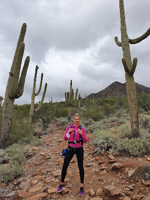
All'interno della riserva, uno dei luoghi più amati dagli abitanti di Phoenix e dintorni, non mancano le possibilità di trail, su tutti spicca il famosissimo McDowell Sonoran Preserve Gateway Trail (Gateway Loop Trail), un percorso in loop di 7.2 km tra i più semplici del parco. 

Within the reserve, which is one of the most loved places by the inhabitants of Phoenix and its surroundings, there is no shortage of trail possibilities, above all the famous McDowell Sonoran Preserve Gateway Trail (Gateway Loop Trail), a 7.2 km loop trail between among the easiest of the entire  park.

Una passerella vi conduce all'inizio del percorso (molto semplice da seguire), che in avvio è un mini loop trail (bajada loop trail) che consente al visitatore di immergersi, tramite pannelli esplicativi, nella flora e nella fauna di questa parte dell'Arizona. 

A boardwalk leads you to the beginning of the path (very easy to follow): it begins with a mini loop trail (bajada loop trail) which allows the visitor to learn more, through explanatory panels, about flora and fauna of this part of the Arizona.


Poi, di fatto, comincia quello che è il vero trail, da percorrere, se possibile, in senso orario, un percorso adatto anche a chi fa jogging o chi ha con sé una bici mountain bike. In cima al Saddle Gatweay si avrà una discreta vista sulla vallata sottostante. Di tutti i trail che abbiamo percorso nel viaggio del sud dell'Arizona, il Gateway Trail è quello che ci ha entusiasmato di meno, ma per il semplice fatto che gli altri erano davvero belli...

LUNGHEZZA: loop di 7.2 km

DISLIVELLO: 230 metri

The actual trail begins right there and we suggest to follow it in a clockwise direction. This is a path also suitable for joggers or those who are riding a mountain bike. At the top of Saddle Gatweay you will also get a decent view of the valley below. Of all the trails we hike during the Southern Arizona road trip, the Gateway Trail was the least thrilled to us. Why? Just because the others were really beautiful ...

LENGTH: loop of 7.2 km

ELEVATION GAIN: 230 meters

Se, a differenza nostra, avrete un giorno pieno a disposizione, vi consigliamo di dirigervi verso sud (circa 30 miglia) e percorrere a Gilbert un altro semplice trail di 3 km, il Water Ranch Trail, un percorso ad anello situato all'interno del Riparian Preserve at Water Ranch, dove grazie ad un bel boardwalk potrete ammirare la fauna del luogo. E' una passeggiata decisamente rilassante (2.1 km in loop)


CITTA': Phoenix (Chandler)

HOTEL: Homewood Suites by Hilton Phoenix Chandler/Fashion Center

Per 4 notti è stata la nostra casa e, nonostante la posizione defilata (sud-est), è stata un'ottima sistemazione. Il monolocale era molto grande e la colazione decisamente ampia. Consigliato.


If, unlike us, you have all day, we suggest you head south (about 30 miles) and hike another easy 2-mile trail in Gilbert, the Water Ranch Trail, a loop trail located within the Riparian Preserve at Water Ranch, where thanks to a nice boardwalk you can admire the local wildlife. It's a decidedly relaxing walk (2.1 km loop trail)


CITY: Phoenix (Chandler)

HOTEL: Homewood Suites by Hilton Phoenix Chandler/Fashion Center

For 4 nights this was our home and despite the secluded position (southeast), it was a great accommodation. The studio apartment was very large and the breakfast definitely hearty. Recommended.


© RIPRODUZIONE RISERVATA


© COPYRIGHT - ALL RIGHTS RESERVED


FOLLOW US ON FACEBOOK: WWW.FACEBOOK.COM/DUECUORIPERVIAGGIARE?REF=HL


venerdì 1 aprile 2022

The best of Phoenix and Tucson: 10 days exploring the "land of cactus" (Day 2 - Phoenix: Echo Canyon Recreational Area, Pinnacle Peak Trail and Scottsdale)

Phoenix, o meglio l'intera "The Valley" e hike è un connubio da sempre vincente. Certo, come abbiamo già abbondantemente detto, non bisogna mai e poi mai sottovalutare le temperature infernali di quest'area dell'Arizona e neppure la wildlife non sempre "amichevole" (serpenti a sonagli e puma su tutti), ma sarete sempre ripagati da sentieri ben tenuti, ben segnalati e, anche se non lo direste mai, decisamente affollati. Soprattutto nella "greater area of Phoenix", ovvero in tutte quelle cittadine più o meno grandi che compongono l'area metropolitana di Phoenix. La prima vera giornata abbiamo scelto di spenderla a nord-est, nei dintorni della splendida Scottsdale, ma i nostri piani sono stati clamorosamente messi in crisi già alle 8 del mattino, quando una volta arrivati al parcheggio del Echo Canyon Recreational Area (dopo aver studiato in lungo e in largo ogni singolo dettaglio del percorso, compreso dove parcheggiare...), non abbiamo trovato alcuna auto. "No, non è possibile, questo è il trail più impegnativo e famoso della città, tanto che per definirti un vero abitante di Phoenix devi aver percorso questo trail. No, non può non esserci nessuno". E, infatti, un motivo c'è. Il trail è chiuso per una frana e, nel momento in cui scriviamo, non sappiamo ancora quando riaprirà...

Phoenix, or rather the whole "Valley", and hiking has always been a winning combination. Of course, as we have already said, you should never underestimate the infernal temperatures of this area of Arizona and even the wildlife is not always "friendly" (rattlesnakes and pumas above all), but hikers will always be rewarded by well-maintained trails, well marked and, although you would never say it, definitely crowded. Especially in the "greater area of Phoenix", aka all those small towns more or less big that make up the metropolitan area of Phoenix. We decided to spend the first entire day in the northeast, in the surroundings of the beautiful Scottsdale, but our plans were resoundingly put into crisis already at 8 am, when once we got to the parking lot of the Echo Canyon Recreational Area (we also researched where to park because it's not so easy!), we just found no car. "No, that's not possible, this is the most challenging and famous trail in the city of Phoenix, so much so that if you wanna call yourself a true Phoenix resident, welll... you must have done this hike! No they can't not be there". Anyway, there is a reason for that. The trail is closed due to a landslide and, at the time of this writing, we still don't know when it will reopen....

(Scottsdale)

Tuttavia, proprio perchè l'avevamo studiato in lungo ed in largo, vogliamo comunque darvi qualche indicazione che potrà risultare utile quando la municipalità di Phoenix deciderà di riaprirla. Perchè, pur essendo un trail cittadino, è un'autentica scalata decisamente impegnativa, anche se di breve distanza, capace di richiamare oltre 450.000 persone ogni anno. Ed alcuni dei quali (circa 200 all'anno) non solo non riescono a completarlo ma, complice il gran caldo, devono essere recuperati dai vigili del fuoco. Il nome ufficiale del trail è Camelback Mountain Hike – Cholla Trail, un "point to point" hike di 5 km (400 metri di dislivello) che consigliamo di intraprendere dal versante est, dopo aver lasciato la vostra vettura a ridosso della E Cholla Ln, a Paradise Valley. Una volta arrivati in cima alla Camelback Mountain (a metà percorso), consigliamo di tornare indietro verso il parcheggio. Il trail in realtà è molto semplice da seguire ed è sempre molto affollato, ma in alcuni tratti è davvero molto ripido e ricco di rocce da superare. Ma la vista in cima è davvero impagabile

However, precisely because we've researched everything up and down, we still want to give you a few tips that may be useful when the municipality of Phoenix will decide to reopen it. Because, even though it is an urban trail, it is a very challenging climb (even though it's short), capable to attrcact over 450,000 people every year. And some of them (about 200 per year) not only fail to complete it but, due to the heat, have to be rescued. The official name of the trail is Camelback Mountain Hike - Cholla Trail, a 5 km point-to-point hike (400 meters of elevation gain) that we suggest to start from the east side, after leaving your car near the E Cholla Ln, in Paradise Valley. Once you get to the top of Camelback Mountain (halfway up), we recommend to turn back towards the parking lot. The trail is actually very easy to follow and is always very crowded, but in some sections it is really very steep and full of rocks to overcome. But the view at the top is really priceless.

"E ora cosa facciamo?" Niente panico, il piano B è sempre pronto. E allora ci spostiamo ancora più a nord (30 km, ricordatevi le infinite distanze a Phoenix...) per fare un altro trail, il Pinnacle Peak all'interno del Pinnacle Peak Park. Volete la verità? Questo è stato uno dei percorsi che più ci è piaciuto, in primis perchè non impegnativo e poi per le viste che ci ha regalato su un'area, quella a nord di Scottsdale, decisamente ricca, con campi da golf splendidi e case davvero incredibili. E poi la gente, parecchia ovviamente, ma che ci è sembrata essere esclusivamente del luogo, quasi come se questo percorso fosse una sorta di oasi per gli abitanti di Scottsdale e dintorni. Una volta arrivati all'inizio del percorso (versante est) noterete un piccolo visitor center nel caso doveste aver bisogno di qualche particolare informazione: una volta superato, comincia il vero trail che è un altro "point to point", ovvero dovrete mettere in conto di tornare indietro se voleste completarlo. 

"What do we do now?" Don't panic, Plan B is always ready. So we move further north (20 miles, remember the endless distances in Phoenix...) for another hiking trail called Pinnacle Peak, located within the Pinnacle Peak Park. Do you really want the truth? This was one of the trails we liked the most, first of all because it was not difficult at all and then because it gave us amazing views of an area, north of Scottsdale, which is very rich, with beautiful golf courses and incredible houses. And then there were the people, many people of course, but they seemed to be exclusively local, almost as if this trail were a sort of oasis for the inhabitants of Scottsdale and its surroundings. Once at the beginning of the trail (east side), there's a small visitor center in case you need some particular information: once you pass it, the real trail begins. It's another "point to point", meaning that hikers have to turn back if they want to complete it. 

(Pinnacle Peak)

IL TRAIL NEL DETTAGLIO - TRA CACTUS E VISTE INCREDIBILI

La star di questo spettacolo escursionistico è il Pinnacle Peak stesso, che dominerà immediatamente la tua vista sin dal parcheggio. Non è particolarmente alto, ma questa piccola cima è caratterizzata da alcuni massi davvero puliti e le guglie rocciose stesse sono sicuramente imponenti.

THE TRAIL - AMONG SAGUAROS AND AMAZING VIEWS

The star of this hiking trail is the Pinnacle Peak itself, which has been dominating the view since the parking lot. It's not particularly high, but this little peak features some really neat boulders and the rock spires themselves are definitely impressive

(Pinnacle Peak Trail)

Il percorso comincia subito in salita e, se avrete parcheggiato nel versante est (quello del visitor center, per intenderci), troverete diversi pannelli esplicativi che raccontano sia la flora che la fauna del luogo. Una volta in cima, ad attendervi ci sarà il view point principale del parco (il Pinnacle Peak lookout point), prima della discesa verso la valle. Da qui la vista è davvero impagabile.

The trail begins immediately uphill and, if you are coming from on the east side (the one of the visitor center, to be clear), you'll notice several explanatory panels that tell both the flora and fauna of the place. Once at the top, the main viewpoint of the park (the Pinnacle Peak lookout point) will be waiting for you, before the descent towards the valley. The views from here are truly priceless.


Proprio la discesa nella parte centrale del trail è quella che più ci è piaciuta, tra l'ammirazione delle splendide case con piscina degne di Hollywood e la natura sempre imponente in questa parte degli Stati Uniti. A 3/4 del percorso si torna a salire: questa è decisamente la parte più impegnativa del trail, ma una volta arrivati in cima alla seconda collina, avrete una nuova e più completa visuale sulla valle. Una volta scesi arriverete alla conclusione del trail e da qui dovrete tornare sui vostri passi. 

The descent to the central part of the trail is what we enjoyed the most, among the beautiful houses with swimming pool worthy of Hollywood and the nature always impressive in this part of the United States. At the end of the route, the trail starts to climb again: this is definitely the most challenging part of the trail, but once you get to the top of the second hill, you'llhave a new and more complete view of the valley. Once down there's the end of the trail and from here hikers have to retrace their steps.

("Not a loop trail sign" - Pinnacle Peak)


PINNACLE PEAK TRAIL INFO

LUNGHEZZA: 3.50  miglia a/r

DIFFICOLTA: da moderata a difficile a causa dell'inclinazione, in particolare nella parte finale del sentiero

DISLIVELLO:  1.300 piedi (400 metri)

INDIRIZZO: 26802 N 102nd Way, Scottsdale


PINNACLE PEAK TRAIL INFO

LENGTH: 3.50 miles round trip

DIFFICULTY: moderate to difficult due to incline, particularly on the final portion of the trail

ELEVATION GAIN: 1,300 feet (400 meters)

ADDRESS: 26802 N 102nd Way, Scottsdale

SCOTTSDALE, "THE WEST'S MOST WESTERN TOWN"

"La città più western del west". No, non siamo noi a definire così la bellissima cittadina di Scottsdale, bensì il suo primo sindaco, tale Malcolm White (1951), un motto che dopo oltre 70 anni continua a definire l'anima di una città che a parer nostro è seconda soltanto a Sedona come bellezza per quanto riguarda l'Arizona. Perchè è così bella? Per tanti motivi. Oltre ad avere il più alto numero di spa di lusso dell'intero paese (a conferma di quanto qui si viva bene...), il crescente numero di ristoranti e nightclub di lusso, gallerie alla moda e tanti luoghi per lo shopping, Scottsdale è vibrante sotto ogni punto di vista. Perchè a fianco della old town dai caratteri tipicamente western, c'è una Scottsdale adatta ai giovani, alle famiglie...insomma a tutti. 

"The west's most western town" No, this is not how we define the beautiful town of Scottsdale, but rather its first mayor, Malcolm White (1951), a motto that has been defining for over 70 years the soul of a city that in our opinion is second in beauty only to Sedona in Arizona. Why is it so beautiful? For many reasons. In addition to having the highest number of luxury spas in the entire country (it just confirms its whealt), the growing number of upscale restaurants and nightclubs, trendy galleries and many shopping venues, Scottsdale is vibrant in every way. Because next to the old town with its typical western character, there is a Scottsdale suitable for young people, families...in short, for everyone. 

("the west's most western town bench - old town Scottsdale)

Scottsdale è principalmente nota soprattutto per la sua caratteristica Old Town, nella quale si può vagare senza meta, immergendosi nella pittoresca atmosfera western, fatta di negozi di souvenir, edifici ricostruiti in stile western, statue di indiani e cowboy a cavallo e gli immancabili saloon. In Arizona non mancheranno i luoghi dove "tornare indietro nel tempo di almeno 100 anni", e la old town di Scottsdale è decisamente un buon punto di partenza.

Scottsdale is mainly known for its characteristic Old Town, where you can wander aimlessly, immerse yourself in the picturesque western atmosphere, made of souvenir stores, buildings reconstructed in western style, statues of Indians and cowboys on horseback and the inevitable saloons. In Arizona, there is no shortage of places to "go back in time", and the old town of Scottsdale is definitely a good starting point.

Però non è assolutamente finita qui. Lasciate pure l'auto a ridosso della oldtown (se le temperature lo consentono) e percorrete a piedi per circa 1 km la N Scottsdale Rd in direzione fiume, sino a raggiungere la 5th avenue. 

But this is not the end of the story. Leave your car close to the oldtown (if the temperatures allow it) and walk for about 1 km along N Scottsdale Rd towards the river, until you reach the 5th avenue. 

(N Scottsdale Rd)

Un cartello enorme che recita "5th avenue shops" vi darà il benvenuto nell'area dello shopping, dove non mancano neppure ristoranti e birrerie. Negozi di qualità si alternano a quelli di souvenir, ristoranti di classe si alternano invece a birrerie spartane. Percorretela interamente (una sorta di semicerchio) sino ad arrivare al fiume. Qui potrete scattare foto pittoresche e percorrere anche un tratto scenografico di river-front. Dall'altra parte del fiume (dopo aver attraversato il south bridge) ad attendervi ci saranno appartamenti di altissimo livello e diversi grandi magazzini. Su tutti Nordstrom, davvero molto grande. Poco più a nord c'è anche un centro commerciale (Scottsdale Fashion Square): insomma ci sono tutti gli ingredienti per spendere una giornata (o un pomeriggio, come nel nostro caso), davvero rilassante...

A huge sign that says "5th avenue shops" welcomes you to the shopping area, where there is no shortage of restaurants and breweries. Quality stores alternate with souvenir stores, classy restaurants alternate with spartan breweries. Walk along the entire street (a sort of semicircle) until you reach the river. Here you can take picturesque photos and also walk along a scenic stretch of the river-front. On the other side of the river (after crossing the south bridge) you will find very high level apartments and several department stores. Above all Nordstrom, very large indeed. A little further north there is also a shopping center (Scottsdale Fashion Square): in short, there'everything for a relaxing day. Or just an afternoon, as in our case.


© RIPRODUZIONE RISERVATA


© COPYRIGHT - ALL RIGHTS RESERVED


FOLLOW US ON FACEBOOK: WWW.FACEBOOK.COM/DUECUORIPERVIAGGIARE?REF=HL


venerdì 25 marzo 2022

The best of Phoenix and Tucson: 10 days exploring the "land of cactus" (Day 3 - Phoenix: Usery Mountain Regional Park & the amazing Apache trail)

C'è una giornata sempre speciale quando si visita Phoenix, anzi diciamo pure le cose come stanno, e definiamola non solo speciale, ma semplicemente la più bella in assoluto. E' quella dell'Apache Trail, un luogo, anzi una strada, che racchiude l'essenza del west, un tempo casa della tribu indiana Apache che era solito utilizzare questo percorso per attraversare le insidiosissime Superstition Mountain. L'Apache trail è un viaggio nel viaggio, un'escursione di un'intera giornata che comincia e si conclude a ad Apache Junction, un loop di circa 200 km che fà davvero respirare quella magica atmosfera che solo il west americano sa regalare. Ma, purtroppo, ancora oggi e dopo tre anni (2019-2022), la tortuosissima strada dell'Apache Trail è ancora chiusa a causa di una frana che ha sostanzialmente distrutto una parte di carreggiata, rendendo di fatto impossibile percorrere l'intero loop. E, quella che sarebbe dovuta essere un'intera giornata a spasso nel west, è diventata una breve escursione di qualche ora. Per questo, dunque, abbiamo deciso di inserire nella prima parte di giornata un bel trail lungo la strada, dedicando alla seconda parte una buona fetta di Apache Trail. Ma non preoccupatevi, noi l'Apache Trail ve lo raccontiamo nella sua interezza...

There is one day that is always special when visiting Phoenix, or let's face it and call it not only special, but simply the most beautiful day in the Valley. It's the Apache Trail, a place, or rather a road, that encapsulates the essence of the west, once home to the Apache Indian tribe that used to use this trail to cross the treacherous Superstition Mountain. The Apache trail is a journey within a journey, an a road trip day that begins and ends at Apache Junction: it's a loop of about 200 km that really lets you breathe in that magical atmosphere that only the American West can offer. But, unfortunately, even today and after three years (2019-2022), the winding road of the Apache Trail is still closed due to a landslide that has essentially destroyed part of the roadway, making it impossible to travel the entire loop. And, what should have been a full day along the Apache Trail, has instead become a short excursion of a few hours. Therefore, we decided to include a nice trail along the road in the first part of the day, and then spent the afternoon driving the first stretch of the Apache Trail. But don't worry, we will tell you about all the things you should not miss along the Apache Trail...

(Goldfield Ghost Town - Apache Trail)

L'INCREDIBILE VISTA SULLA VALLATA CHE REGALA IL WIND CAVE TRAIL...

L'Apache Trail non può essere percorso interamente? Poco male, ad ad una manciata di km ad est di Phoenix, proprio proco prima dell'inizio della storica strada panoramica, c'è un parco regionale (ingresso: 7 dollari a veicolo) davvero carino, l'Usery Mountain Regional Park,  "famoso" anche per il fatto che da diversi dei suoi sentieri è possibile notare il lontananza la scritta "Phoenix" con la freccia sulla montagna, utile per gli aerei che devono atterrare allo Sky Harbor Airport. Qui ce n'è davvero per tutti i gusti, partendo dai trail più semplici adatti a tutta la famiglia, con il "Merkle hill - Vista Trail", un loop di 0.8 km con dislivello di 40 metri che è una sorta di buon punto di partenza per l'esplorazione del parco. 

THE WIND CAVE TRAIL AND THE BEAUTIFUL VIEW OF THE VALLEY

The Apache Trail can't be covered in its entirety? No problem, a few kilometers east of Phoenix, just before the beginning of the historic scenic route, there is a really nice regional park (admission: $7 per vehicle), the Usery Mountain Regional Park,  "famous" for the fact that the sign "Phoenix" with the arrow on the mountain, useful for planes that have to land at Sky Harbor Airport, can bee seen from several of its trails. There is something for everyone here, starting with the easiest trails suitable for the whole family, for example the "Merkle hill - Vista Trail", a 0.8 km loop with an elevation gain of 40 meters that is a sort of good starting point for exploring the park. 

(Merkle trail sign)

Sono tanti gli amanti del campeggio che spendono intere giornate in questo tranquillissimo ma allo stesso tempo affascinante parco, così come le famiglie che spendono qualche ora nella più totale tranquillità percorrendo uno dei tanti sentieri. 

There are many campers who spend entire days in this quiet but at the same time fascinating park, as well as families who spend a few hours in total tranquility along one of the many trails.

Ma il trail davvero da non perdere è il Wind Cave, semplicemente perchè diverso da tutti gli altri. C'è una "ricompensa" alla fine del percorso e non soltanto cactus che comunque rimangono sempre splendidi. Il Wind Cave trail è un percorso di 4.8 km (2.4 sola andata) con un dislivello di quasi 300 metri che non vi deluderà. Il trail, in salita (all'andata), vi consentirà di avvicinarvi al Pass Mountain, una montagna decisamente colorata e fotogenica. 

But the trail really not to be missed is the Wind Cave, simply because it is different from all the others. There is a "reward" at the end of the trail and not just cacti that are still beautiful. The Wind Cave is a 4.8 km trail (2.4 one way) with an elevation gain of almost 300 meters that will not disappoint you. The trail, uphill (one way), allows hikers to get closer to Pass Mountain, a very colorful and photogenic mountain. 

(wind cave trail -the last part)


(the "wind cave")

Una volta raggiunta la cima, non solo avrete la possibilità di ammirare l'intera vallata e la scritta "Phoenix", ma cave stessa è un luogo dove fermarsi per godere appieno della splendida vista. Ad essere onesti, quella che tutti chiamano "cave", grotta, è in realtà un'alcova, situata ad 800 metri sul livello del mare.

Once at the top, you'll get the chance to admire the entire valley and the "Phoenix" sign, but cave itself is a place to stop and enjoy the beautiful view. To be honest, what everyone calls "cave" is actually an alcove, located 800 meters above sea level.

Lo strato indurito di cenere vulcanica che la circonda risale all'incirca a 14-15 milioni di anni fa ed è da sempre casa di api e soprattutto scoiattoli, abituati a ricevere cibo dai visitatori. 

The hardened layer of volcanic ash that surrounds it, dates back approximately 14-15 million years and has always been home to bees and especially squirrels, used to receiving food from visitors. 


L'APACHE TRAIL 

IL WEST AL SUO MEGLIO NELLA STRADA PIU' TORTUOSA DELL'INTERA ARIZONA

Apache Junction è la cittadina "gate town" di quella che a tutti gli effetti una delle strade panoramiche più affascinanti degli interi Stati Uniti, l'Apache Trail, un mix tra cactus (immancabili), laghi blu, canyons colorati ed una strada, per gran parte sterrata, considerata tra le più terrificanti dello stato. Questo e molto altro è l'Apache Trail, un tratto di Arizona che ci parla di un passato sì lontano... ma ancora molto presente, fatto di nativi americani e dei loro pueblos, di corsa all'oro e di cittadine minerarie ora diventate ghost town, di saloon e sparatorie, ma anche di una bellissima natura ancora incontaminata lungo una strada costruita originariamente nel 1930 per sostenere lo sviluppo di dighe lungo il Salt river ed ora ormai diventata una delle Scenic byway più belle degli Stati Uniti. Anzi Scenic and Historic Highway, l'unica in Arizona. 

THE APACHE TRAIL 

THE WEST AT ITS BEST ON THE MOST WINDING ROAD IN ALL OF ARIZONA

Apache Junction is the gate town to one of the most fascinating scenic roads in the entire United States, the Apache Trail, a mix of cacti, blue lakes, colored canyons and a road, mostly unpaved, considered among the most terrifying in the state. This and much more is the Apache Trail, a stretch of Arizona that tells us of a distant past... but still very present, made of Native Americans and their pueblos, of gold rush and mining towns now become ghost towns, of saloons and gunfights, but also of a beautiful nature still untouched along a road originally built in 1930 to support the development of dams along the Salt River and now become one of the most beautiful Scenic byways in the United States. Indeed Scenic and Historic Highway, the only one in Arizona. 

(Goldfield Ghost Town)

Il percorso si snoda lungo la AZ88 (per larghi tratti sterrata), attraversa Roosevelt e poi a sud verso Globe e di nuovo ad Apache Junction. Si percorre un loop di circa 120 miglia in uno scenario spettacolare tra i più belli dell’intero Stato dell’Arizona.

The route winds along AZ88 (which is unpaved for large stretches), through Roosevelt and then south to Globe and back to Apache Junction. It is a 120 miles loop in some of the most spectacular scenery in the entire state of Arizona.

(Superstition Mountain Museum)

Come detto, l'Apache Trail comincia dalla cittadina di Apache Junction ed il primo segno western arriva con l'Hitching Post Saloon, al cui esterno troverete un murales e la ricreazione di un villaggio. E sullo sfondo, sempre e comunque le insidiosissime Superstition Mountain.

As mentioned, the Apache Trail begins in the small town of Apache Junction and the first western sign comes with the Hitching Post Saloon. Just outside the saloon, you'll find a mural and a recreation of a village. And in the background, always and forever the treacherous Superstition Mountains.

(Hitching Post Saloon - murales)

Neppure un km dopo, sulla destra, ecco comparire il Superstition Mountain Museum (che noi abbiamo trovato chiuso), un museo a cielo aperto che racchiude edifici utilizzati come set cinematografico negli anni d'oro del cinema western di Hollywood. Un sentiero pedonale conduce il visitatore tra gli edifici che hanno fatto la storia di molti film, in una location semplicemente perfetta. il motivo? Sempre lo stesso, perchè lo sfondo sono sempre le Superstition Mountains.

Just one km later, on the right, there's the Superstition Mountain Museum (which it was closed when we visited it), an open-air museum that includes buildings used as movie sets in the golden years of Hollywood western cinema. A pedestrian path leads visitors among the buildings that have made the history of many movies, in a location that is simply perfect. the reason? It's still the same, because the backdrop is made by the Superstition Mountains.

(Superstition Mountain Museum)

Ma tutto il west  che c'è nell'Apache Trail deve ancora uscire allo scoperto. Basta, infatti, percorrere ancora un km e, sulla sinistra, ecco comparire uno dei fiori all'occhiello della "88", la ghost town di Goldfield. Nel 1892 era, di fatto, l'epicentro di tutta questa area: poi, una volta esaurito l'oro nella vicina Mammoth mine (che produsse tre milioni di dollari in oro tra il 1892 ed il 1896), visse come altre cittadine minerarie un brusco e repentino crollo. 

But all the west that is in the Apache Trail has yet to come out. In fact, visitors have just to travel another kilometer and get to one of the crown of the road "88", the ghost town of Goldfield. In 1892 it was, in fact, the epicenter of this entire area: then, once the gold in the nearby Mammoth mine (which produced three million dollars in gold between 1892 and 1896) was exhausted, it experienced, like other mining towns, a sudden and abrupt collapse. 

(Goldfield Ghost Town)

La cittadina è ora un insieme di edifici repliche che ricordano quel momento di massimo splendore, con negozi di souvenir e artigianato, ristoranti, un piccolo museo e un’attrazione particolare, il vecchio Bordello. Oltre ovviamente alla miniera. A passeggiare con voi ci saranno anche fuorilegge, prostitute e anche marshalls... e uno dei quali non si è lasciato sfuggire l'occasione di arrestare il povero Marco. 

The town is now a collection of replica buildings reminiscent of that heyday, with souvenir and craft stores, restaurants, a small museum and a special attraction, the old Bordello. Together withe the old mine, of course. You'll notice outlaws, prostitutes and even the marshalls.... which did not miss the opportunity to arrest the poor Marco. 

(Goldfield jail)

Nel 1890 Goldfield vantava 3 saloni, una pensione, un grande magazzino, un fabbro, un birrificio, un mercato della carne e una scuola. Ora è diventato una sorta di parco a tema, con diverse attrazioni, adatte a grandi e piccini (tutte a pagamento) che renderanno ancor più affascinante la vostra avventura a Goldfield. 

In 1890 Goldfield boasted 3 saloons, a hotel, a department store, a blacksmith, a brewery, a meat market and a school. Just when it looked like the town would outgrow Mesa, the vein faulted, the grade of ore dropped and the town died a slow painful death. It has now become a theme park, with several attractions, suitable for kids and adults (all for a fee) that will make your Goldfield adventure even more fascinating. 

(Goldfield cowboys)

Su tutte il Superstition Narrow Gauge Railroad (10 dollari), il treno a scartamento 36 "della Superstition Scenic Narrow Gauge Railroad, la Superstition Zipline, il Goldfield Mine Tours (10 dollari), ovvero il tour della miniera che regalò tonnellate di argento oltre 100 anni fa ed infine anche il The Mystery Shack (7 dollari), dove dovrete lottare con la forza di gravità.

Above all we mention the Superstition Narrow Gauge Railroad ($10), the 36" gauge train of the Superstition Scenic Narrow Gauge Railroad, the Superstition Zipline, the Goldfield Mine Tours ($10), which is a tour of the mine that gave away tons of silver over 100 years ago and finally also The Mystery Shack ($7), where you will have to fight with gravity.


Gli appassionati di Hiking potranno invece attraversare la strada ed entrare nel Lost Dutchman state park, un bellissimo ma altrettanto insidioso parco statale (molti hikers si perdono ed alcuni sono addirittura deceduti...) ricco di fascino e di una particolare storia. Al suo interno, infatti, pare sia nascosta una miniera d'oro che la leggenda vuole infestata dagli spiriti di coloro che sono morti per cercarla. Il nome del parco, infatti, non è per nulla casuale. Il Centro visitatori Lost Dutchman è aperto 365 giorni all'anno e comprende un negozio di articoli da regalo e interessanti mostre naturali. Nel caso vogliate visitarlo, consigliamo questi due semplici trail: il primo è il Native Plant Trail, un brevissimo percorso di 400 metri a ridosso del visitor center e soprattutto il Treasure Loop Trail (2.3 miglia). Dopotutto, siamo o non siamo tutti qui per il tesoro nascosto?

GLI ALTRI STOP LUNGO L'APACHE TRAIL

Il vero Apache Trail però comincia qui, dopo aver lasciato il Lost Dutchman State Park. La civiltà finisce e si lascia spazio ancor di più alla natura, anche se per almeno una ventina di km la strada sarà ancora asfaltata. In questo tratto di scenic bway ci si affaccia spesso sul Canyon Lake ed il view point principale è sicuramente il Canyon lake e canyon lake vista, dove potrete ammirare l'omonimo lago, uno dei 4 formatisi con lo sbarramento del Salt River. Da qui è possibile scendere verso il porto turistico e salire sulla Steamboat Dolly, per diversi tour sul lago disponibili durante tutto il giorno.

Hiking enthusiasts can instead cross the road and enter the Lost Dutchman State Park, a beautiful but equally treacherous state park (many hikers got lost and some have even died there ...), full of charm and a particular story. In this park, in fact, it seems to be hidden a gold mine that legend says is haunted by the spirits of those who died twhile trying to find it. The name of the park, in fact, is not random at all. The Lost Dutchman Visitor Center is open every day and includes a gift store, and interesting nature exhibits. In case you want to visit the park, we recommend these two easy trails: the first one is the Native Plant Trail, an easy quarter-mile trail that starts behind the visitor center, and especially the Treasure Loop Trail (2.3 miles). After all, we are here for the hidden treasure. Or not?

OTHER STOPS ALONG THE APACHE TRAIL

The real Apache Trail begins here though, after leaving the Lost Dutchman State Park. Civilization ends and more space is left to nature, even if the road will still be paved for at least 10 miles. In this stretch of scenic bway you often overlook the Canyon Lake and the main viewpoint is definitely Canyon lake and canyon lake vista, where you can admire the homonymous lake, one of the 4 formed by the damming of the Salt River. From here you can go down to the marina and get on the Steamboat Dolly, for several tours on the lake available throughout the day.


Tortilla Flat è invece l'unico baluardo di civiltà, una sorta di set cinematografico di un film western "vero". Già, perchè qui si vive per davvero, anche se la più piccola comunità dell'Arizona conta una popolazione di sole sei persone!

Tortilla Flat, on the other hand, is the only bastion of civilization, a sort of real set of a western movie. That's right, because people really live there, even though the Arizona's smallest community has a population of only six people!

(Tortilla Flat)

Nata come sosta per le diligenze dei trasportatori durante la costruzione della Roosvelt Dam, resta tuttora un punto di sosta per i turisti. Una visita al Tortilla Flat Saloon è un must quando si percorre l'Apache Trail. Il ristorante, sempre affollato, è tappezzato di dollari firmati dai turist: gli sgabelli al banco del bar sono a sella di cavallo, il juke box e le bandiere sono lì a creare un'atmosfera davvero unica...

Established as a staging point for carrier stagecoaches during the construction of Roosevelt Dam, it still remains a staging point for tourists. A visit to the Tortilla Flat Saloon is a must when traveling the Apache Trail. The restaurant, always crowded, is plastered with dollars signed by tourists: the stools at the bar counter are saddle horses, the juke box and the flags are there to create a truly unique atmosphere...

(Tortilla Flat Saloon)

Questo tratto di Apache Trail, conosciuto come la "Sunset route " dal 1915-1932, è il più bello perchè poco dopo aver lasciato Tortilla Flat diventa sterrato. E che sterrato. No, l'Apache Trail da qui sino Fish Creek Hill è impegnativo e panoramico, anche se noi abbiamo potuto percorrerne solamente un tratto per via della già menzionata chiusura, circa 7 km dopo Tortilla Flat. Vorrete fermarvi ad ogni angolo per scattare foto ai bellissimi panorami che l'Apache Trail sa regalare, almeno fino a Fish Creek Hill Viewpoint: da qui, inizia una ripida discesa e dovrete prestare attenzione solo a guidare! 

This section of the Apache Trail, known as the "Sunset route" from 1915-1932, is definitely the most beautiful because, shortly after leaving Tortilla Flat, it becomes a dirt road. One of the best road of the entire Arizona. The Apache Trail, from here to Fish Creek Hill, is challenging and scenic, although we could only ride a small portion of the road because of the aforementioned closure, about 7 km after Tortilla Flat. You'll want to stop at every corner to take pictures of the beautiful views that the Apache Trail has to offer, at least until Fish Creek Hill Viewpoint: from here, a steep descent begins and you'll only have to pay attention to driving! 

Proprio qui il nostro viaggio lungo l'Apache Trail si è interrotto, e ci siamo dovuti accontentare del bellissimo e semplice trail che conduce alla scenic vista: da qui ci siamo goduti la miglior vista sul canyon, con la prosecuzione dell'Apache Trail sullo sfondo.

Our trip along the Apache Trail was stopped right here, and we had to settle for the beautiful and simple trail that leads to the scenic vista: this is the best view of the canyon, with the continuation of the Apache Trail in the background.

(Apache Trail - Road closed at Fish Creek Hill)

Quando l'Apache Trail riaprirà completamente i battenti, qui inizierà la discesa verso Apache Lake. 450 mt di dislivello in 5 km sempre di sterrata, dove la prudenza mentre guiderete non sarà mai troppa. L'acque dell'Apache Lake, di un blu molto forte, contrasterà con il rosso del canyon ed il verde dei cactus. 

When the Apache Trail reopens, the descent towards Apache Lake will begin here. 450 meters of elevation gain in 5 km of dirt road, where caution while driving is never enough. The water of Apache Lake, which is deep blue, contrasts with the red of the canyon and the green of the cactus. 

Il tratto di sterrata si conclude alla Roosevelt Dam, una diga che prende il nome proprio dal presidente che definì l'Apache Trail come la perfetta combinazione tra le Rocky Mountains ed il Grand Canyon. Originariamente costruita tra il 1905 e il 1910, limita l'acqua del Salt river formando il Roosevelt Lake. Una volta superata la diga potrete scegliere se continuare il percorso lungo l'Apache Trail svoltando a destra lungo la 188, oppure a sinistra sempre lungo la 188 che poi diventerà 87. Svoltando a destra incrocerete il Tonto National Monument, dove potrete ammirare resti di culture vissute qui circa 700 anni fa. I due principali trail che conducono ai due abitati rupestri, sono il percorso di 1.3 km che parte dal visitor center oppure il più lungo trail di 5 km, percorribile però solo insieme alla guida ranger. Anche la via del ritorno lungo l'Apache Trail è ricca di curiosità e luoghi particolari, ma ne parleremo nel prossimo post...

This stretch of dirt road ends at Roosevelt Dam, a dam named after the president who called the Apache Trail the perfect combination of the Rocky Mountains and the Grand Canyon. Originally built between 1905 and 1910, it limits the water of the Salt river forming the Roosevelt Lake. Once past the dam, visitors can choose to continue along the Apache Trail, turning right onto road 188, or left onto 188 which will then become 87. People who decide to turn right will come across Tonto National Monument, home of remains of cultures that lived here about 700 years ago. The two main trails that lead to the two cave dwellings are the 1.3 km trail that starts from the visitor center or the longer 5 km trail, which can be followed only with a ranger guide. Even the way back along the Apache Trail is full of curiosities and special places, but we'll talk about it in the next post...

(Apache Trail)


© RIPRODUZIONE RISERVATA


© COPYRIGHT - ALL RIGHTS RESERVED


FOLLOW US ON FACEBOOK: WWW.FACEBOOK.COM/DUECUORIPERVIAGGIARE?REF=HL

venerdì 18 marzo 2022

The best of Phoenix and Tucson: 10 days exploring the "land of cactus" (Day 4 - Phoenix: South Mountain Preserve & Arizona Broadway Theatre)

L'ultima giornata a Phoenix è quella che, tra le quattro spese in "The Valley", ci ha lasciato i ricordi più belli. Non tanto per le avventure outdoor, quelle sempre affascinanti, ma per quanto avvenuto la sera, quando abbiamo assistito alla rappresentazione teatrale del musical natalizio di "Elf", un'esperienza davvero incredibile e che consigliamo davvero a tutti coloro che si troveranno dalle parti di Phoenix. Però questa è stata la conclusione della serata e della nostra esperienza nella sottovalutatissima cittadina dell'Arizona, prima c'è stata tanta avventura che, come al solito, ci ha portato ad esplorare gli angoli nascosti del deserto di Sonora. Partendo da una delle oasi della città che, soprattutto nei mesi più caldi, grazie ai suoi 16mila acri regala in un colpo solo un pizzico di refrigerio, una delle più significative viste su Phoenix e, soprattutto, uno dei tramonti più belli in assoluto.

The last day in Phoenix is the one that, among the four spent in "The Valley", left us with the best memories. Not so much for the outdoor adventures, which are always fascinating, but for what happened in the evening, when we attended the theatrical performance of the Christmas musical "Buddy the Elf", a truly incredible experience that we really recommend to all those visiting Phoenix. But this was the end of the day and of our experience in the underrated Arizona city, but there has also been a lot of adventure that, as usual, led us to explore the hidden corners of the Sonora desert. Starting from one of the city's oasis that, especially in the hottest months, thanks to its 16 thousand acres, gives in one fell swoop a bit of coolness, one of the most significant views of Phoenix and, above all, one of the most beautiful sunsets ever.

(Dobbins Lookout - South Mountain Preserve)


SOUTH MOUNTAIN PARK, 50 MIGLIA DI SENTIERI E VISTE MAGNIFICHE

Il South Mountain Park-Preserve, uno dei più grandi parchi gestiti dalla municipalità della nazione e costituito da tre catene montuose, il Ma Ha Tauk, Gila e Guadalupe, è perfetto per chi ama camminare, grazie alle sue 50 miglia di sentieri, ma anche per chi vuole utilizzare il suo veicolo e raggiungere la vetta per godersi una delle più belle viste su Phoenix. Anzi diciamo pure la più bella. Dovrete raggiungere il sud della città e percorrere la South Central Avenue. Poco dopo aver superato il Visitor Center (ingresso gratuito), la strada cambia nome (Summit road) ed inizierà a salire. Un percorso adrenalinico (la strada è asfaltata) che conduce ai 2330 piedi (700 metri) del Dobbins Lookout, il punto più alto del parco. Da questo belvedere si gode della miglior vista sulla città e anche gli amanti della storia avranno pane per i loro denti. 

SOUTH MOUNTAIN PARK, 50 MILES OF TRAILS AND MAGNIFICENT VIEWS

South Mountain Park-Preserve, one of the largest municipally managed parks in the nation and consisting of three mountain ranges, the Ma Ha Tauk, Gila and Guadalupe, is perfect for those who love to hike, thanks to its 50 miles of trails, but also for those who want to use their vehicle and reach the summit to enjoy one of the most beautiful views of Phoenix. In fact, let's just say the most beautiful. You will have to reach the south of the city of Phoenix and drive down South Central Avenue. Shortly after passing the Visitor Center (admission is free), the road changes name (Summit road) and begins to climb. It's an adrenaline-pumping ride (the road is paved) that leads to the 2330 feet (700 meters) of the Dobbins Lookout, the highest point in the park. From this lookout you can enjoy the best view of the city and history lovers will also have their fill. 

Qui, infatti, troverete anche i resti di un edificio che un tempo era la sede del Civilian Conservation Corps (anni 30 del secolo scorso) e che fu voluto direttamente dal presidente Franklin D Roosevelt come parte del suo programma New Deal.

Here, in fact, visitors will also find the remains of a building that was once the headquarters of the Civilian Conservation Corps (1930s) and was directly desired by President Franklin D Roosevelt as part of his New Deal program.

(Dobbins Lookout - Ruins)

Dobbins Lookout non è tuttavia l'unico view point: la strada, infatti prosegue sino a raggiungere l'ultimo belvedere, il Gila Valley Lookout con la sua "famosa" panchina con vista. Qui la strada s'interrompe e dovrete tornare indietro, senza tuttavia dimenticare che tutti i view point possono essere raggiunti grazie ad impegnativi trail che partono dal fondo valle. 

Dobbins Lookout is not the only viewpoint: the road, in fact, continues until  the last lookout, the Gila Valley Lookout with its "famous" bench with a view. Here the road stops and you'll have to turn back, but don't forget that all the viewpoints can be reached also thanks to challenging trails that start from the bottom of the valley. 

(Gila Valley Lookout - The Bench)

Il trail che abbiamo deciso di percorrere noi, invece, si trova molto distante da questa parte del parco. Dovrete, infatti, tornare a valle, superare il Visitor Center e guidare per quasi venti chilometri sino a quando avrete raggiunto il versante nord-est del parco. Lasciate la vostra auto al 2425 E Valley View Dr (l'indirizzo non è così semplice da trovare) e cominciate la scalata lungo il Mormon Trail. 

However, we decided to hike a trail located far from this part of the park. In fact, we had to go back to the valley, pass the Visitor Center and drive for almost twenty kilometers until we got to the north-east side of the park. Leave your car at 2425 E Valley View Dr (the address is not so easy to find) and start the climb along the Mormon Trail. 

(Mormon Loop Trail - the beginning)

L'intero percorso è di 6 km (dislivello 282 metri) ma la prima parte, ovvero il Mormon Trail, è interamente in salita. Non potrete non voltarvi mentre percorrete gli 1.8 km del Mormon Trail, perchè dietro di voi si aprirà la vallata. Il percorso è abbastanza semplice, seppur in salita, ed è ben segnalato. E soprattutto, almeno in inverno, è decisamente affollato. 

The entire trail is 6 km long (elevation gain: 282 meters) but the first part, the Mormon Trail, is entirely uphill. You won't be able to avoid turning around as you walk the 1.8 km of the Mormon Trail, because the valley will open up behind you. The trail is fairly easy, albeit uphill, and is well marked. Best of all, at least in the winter, it's definitely crowded. 

Una volta raggiunta la cima vi troverete di fronte ad un bivio, tenete la destra e seguite la strada che in discesa, si fionda nella valle nascosta del South Mountain, la Hidden Valley, un autentico paradiso per hikers ed appassionati di Mountain Bike. 

Once you reach the top, there's a fork, keep right and follow the road downhill, slinging in the Hidden Valley of the South Mountain, a true paradise for hikers and mountain bikers. 

Poco dopo un altro bivio delimita l'inizio dell'Hidden Valley Loop Trail, un loop circolare che, di fatto, è anche la parte più bella del percorso. Noi vi consigliamo di seguirlo in senso orario (svoltando dunque a sinistra) e, dopo una manciata di minuti, arriverete quasi a sorpresa al grande highlight del sentiero, lo slot canyon del Fatman's Pass. 

Shortly after, another fork marks the beginning of the Hidden Valley Loop Trail, a circular path that, in fact, is also the most beautiful part of the entire trail. We recommend following it clockwise (turning left): After a handful of minutes you'll get to the trail's big highlight almost by surprise, the Fatman's Pass slot canyon. 

Un tunnel di una decina di metri, creato dalle rocce e sotto di voi la sabbia finissima, vi riporteranno sicuramente con la mente ai grandi parchi dello Utah. Una volta superato lo slot canyon comincia davvero il divertimento.

A tunnel of about ten meters, created by the rocks, and below you the fine sand, will surely bring your mind back to the great parks of Utah. Once past the slot canyon the fun really begins.

Per circa 300 metri, infatti, il trail non è più segnalato e dovrete scavalcare massi piuttosto grandi per seguirlo (nulla di impossibile). Un saliscendi decisamente divertente che farà da preludio alla conclusione del loop: alla sua conclusione dovrete seguire nuovamente il Mormon Trail sino al parcheggio. Considerate almeno un paio d'ore per percorrere questo trail. 

For about 300 meters, in fact, the trail is no longer marked and you will have to climb over rather large boulders to follow the path (nothing impossible). A very funny up and down that will be the prelude to the conclusion of the loop: it's time to get back to the Mormon Trail again until you reach the parking lot. Consider at least a couple of hours to cover this trail. 

CENA E MUSICAL ALL'ARIZONA BROADWAY THEATRE 

UN'ESPERIENZA DA NON PERDERE

Peoria, nord-ovest di Phoenix. Una delle tante cittadine che compongono l'area urbana della più importante città dell'Arizona. Ai più non dirà nulla, e neppure a noi visto che non offre particolari attrazioni. Tranne una, la più bella, l'Arizona Broadway Theatre, che ci ha regalato una delle serate più belle di sempre negli Stati Uniti. Lo sappiamo, quando si parla di entertainment (intrattenimento) e di spettacoli teatrali gli americani sono imbattibili, ma per noi dubbiosi e con pochissima esperienza riguardo questi eventi teatrali (solo una volta assistemmo ad uno spettacolo, nella Broadway di New York), non era così scontato che si potesse trattare di un'esperienza così significativa. 

DINNER AND MUSICAL AT THE ARIZONA BROADWAY THEATRE 

AN EXPERIENCE NOT TO BE MISSED

Peoria, Northwest Phoenix. One of the many small towns that make up the urban area of Arizona's most important city. The name will not mean much to most people, and even to ourselves since it doesn't offer any particular attractions. Except for one, the most beautiful, the Arizona Broadway Theatre, which gave us one of the most beautiful evenings ever in all the 18th trips to the United States. We know, when it comes to entertainment and theatrical shows, Americans are unbeatable, but we had many doubts and had very little experience with these kind of events (we only attended a show once, in New York's Broadway): it wasn't so obvious that it could be such a significant experience. Yet, for so many reasons, it just has been one of those nights.

Eppure, per tanti motivi, lo è stata e la consigliamo vivamente, soprattutto se masticate un po' di inglese o se conoscete la storia dello spettacolo che verrà portato in scena. Perchè assistere ad un evento all'Arizona Broadway Theatre è un'esperienza. Qui non ci sono turisti (se non forse, qualche americano) e potrete vivere l'evento "con la gente del posto". E poi perchè il teatro è del tutto particolare, con tanti piccoli tavoli (per due, quattro o sei persone) ed una vista sempre pulita. Perchè i tavoli? Semplice, perchè l'esperienza all'Arizona Broadway Theatre si vive a 360 gradi. 

We highly recommend it, especially if you understand a little bit of English or just know the history of the show that will be brought to the stage. Because attending an event at the Arizona Broadway Theatre is an experience. There are no tourists here (except maybe, a few Americans) and you can experience the event "with the locals". And then because the theater is quite unique, with lots of small tables (for two, four or six people) and a consistently clean view. Why the tables? Simple, because the Arizona Broadway Theatre gives visitors a 360º experience.

Potrete scegliere, infatti, se assistere solamente allo spettacolo oppure anche cenare al vostro tavolo. Se, come noi, avrete scelto il ticket completo (circa 90 dollari), dovrete arrivare circa 2 ore prima dell'evento per godere della cena che comprende una salad (o zuppa) e la scelta tra tre entrees. Antipasti, bevande e dessert sono esclusi dal prezzo finale. Noi, va detto, siamo anche stati molto, molto fortunati perchè da amanti del film "Elf", la serata è diventata ancor più magica, la degna conclusione di quattro splendidi giorni a Phoenix...

You can choose, in fact, whether to attend only the show or also have dinner at your table. If, like us, you purchase the regular Dinner and Show ticket (about $ 90), you will have to get there about 2 hours before the event to enjoy the dinner that includes a salad (or soup) and a choice of three entrees. Appetizers, drinks and desserts are excluded from the final price. It must be said, that we've been very very lucky because as lovers of the movie "Buddy the Elf", the evening became even more magical, the best end of these four wonderful days in Phoenix...

(Crab Cake - Arizona Broadway Theatre)

TUTTO QUELLO DA NON PERDERE... SE AVRETE QUALCHE GIORNO IN PIU'

No, Phoenix non è soltanto quello che vi abbiamo elencato in questi quattro post. E, nonostante continui ad essere una tappa di passaggio per moltissimi visitatori europei (e come dar loro torto, vista la quantità di bellezze che offre l'Arizona...), rimane una città da vivere, soprattutto se avrete del tempo a disposizione ed avrete già visitato il resto dello stato. Per coloro i quali volessero approfondire le altre "attrazioni" della città, ecco la nostra top 5 dei luoghi da non perdere a Phoenix:

1) Papago Park

E' l'unico dei cinque luoghi di cui parleremo che abbiamo visitato. Anche se brevemente perchè davvero troppo, troppo affollato. Il Papago Park offre di tutto, dai sentieri alla pesca, dal pluripremiato Desert Botanical Garden, allo zoo della città di Phoenix, passando per la Hall of Flame Museum of Flight. Qui ce n'è davvero per tutti i gusti.

EVERYTHING NOT TO BE MISSED... IF YOU HAVE A FEW EXTRA DAYS

No, Phoenix isn't just what we've listed for you in these four posts. Although it continues to be a stop-over place for many European visitors (we can't just blame them, given the amount of beauty that Arizona can offer...), it remains a city to be experienced, especially if you have some time available and have already visited the rest of the state. For those who would like to explore the other attractions of the city, here is our top 5 places not to be missed while in Phoenix:

1) Papago Park

This is the only one of the five places we're going to talk about that we've visited. Although briefly because it's really too, too crowded. Papago Park offers everything from trails to fishing, from the award-winning Desert Botanical Garden to the Phoenix City Zoo, to the Hall of Flame Museum of Flight. It really has something for everyone.

(Papago Park)

Per quanto riguarda la parte escursionistica, i due luoghi più visitati sono sicuramente la Tomba della Caccia del Governatore, raggiungibile con una brevissima passeggiata (è la tomba del primo governatore dell'Arizona, George Hunt) e soprattutto Hole in the Rock, un'affascinante formazione rocciosa situata sul lato est del parco (0.2 miglia). Nel lato est, oltre a Hole in The Rock, consigliamo anche il brevissimo Papago Park Nature Trail, lungo la Ranger Office Loop Trail (strada a senso unico di marcia), mentre ad ovest il più popolare è sicuramente il Double Butte Loop (2.3 miglia).

When it comes to hike, the two most visited places are surely the Governor's Hunt Tomb, reachable with a very short walk (it is the tomb of the first governor of Arizona, George Hunt) and especially Hole in the Rock, a fascinating rock formation located on the east side of the park (0.2 miles). On the east side, in addition to Hole in The Rock, we also recommend the very short Papago Park Nature Trail, along the Ranger Office Loop Trail (one-way road), while to the west the most popular is definitely the Double Butte Loop (2.3 miles).

(Papago Nature Trail)

2) Rawhide Western Town & Event Center

Rawhide Western Town & Event Center è un'autentica replica di una città del 1880 completa di Main Street, sparatorie, corse in treno e diligenza, corse in burro, toro meccanico, parete da arrampicata, pannelli d'oro, galleria di tiro a segno, negozi unici e Steakhouse & Saloon di fama mondiale. Qui c'è inoltre la possibilità di cenare ed assistere a concerti di musica live. 

3) Hayden Tempe Butte 

Hayden Butte Tempe è un parco di 25 acri che regala una splendida vista sulla cittadina di Tempe e, in lontananza, anche su downtown Phoenix. Chiamato anche "A" Mountain, il butte è culturalmente significativo per tre comunità: la popolazione di Tempe, gli studenti e gli ex studenti della Arizona State University e la comunità indiana di Salt River Pima-Maricopa. Hayden Butte Preserve contiene circa 500 petroglifi, o immagini di arte rupestre, realizzati dagli Hohokam tra il 750 e il 1450 d.C. Gli Hohokam, che erano gli abitanti preistorici di questa zona, costruirono centinaia di miglia di canali di irrigazione per la coltivazione del mais. Il trail è di 1 miglio, interamente in salita all'andata. 

4) Victory stairs trail

Victory Stairs è un percorso di andata e ritorno moderatamente trafficato di 0,2 miglia situato ad ovest di Phoenix, che offre viste panoramiche ed è ottimo per tutti i livelli di abilità. Il sentiero è utilizzato principalmente per passeggiate, corsa e gite nella natura. Sono conosciute anche come Verrado Stairs, ovvero una scalinata costruita con il legno della vecchia ferrovia. 

5) Lights of the world

Ispirato ai tradizionali festival delle lanterne cinesi, Lights of the World è un festival di luci e lanterne a tema festivo che viene considerato il più grande del Nord America. L'evento, che si svolge durante l'inizio del nuovo anno presso l'Arizona State Fairgrounds, presenta abbaglianti spettacoli di lanterne che mettono in luce culture e civiltà diverse in tutto il mondo. Più di 10 milioni di luci compongono l'intero display. Oltre agli accattivanti spettacoli di luci, Lights of the World offre anche giochi e giostre e esibizioni quotidiane che spaziano dall'acrobatica alla musica dal vivo. . Ad onor del vero noi l'abbiamo scartato per via delle recensioni non troppo positive trovate su internet.

2) Rawhide Western Town & Event Center

Rawhide Western Town & Event Center is an authentic replica of an 1880's town complete with Main Street, gunfights, train and stagecoach rides, burros races, mechanical bull, climbing wall, gold panels, shooting gallery, unique stores and world-class Steakhouse & Saloon. There is also the opportunity to dine and attend live music concerts here. 

3) Hayden Tempe Butte 

Hayden Butte Tempe is a 25-acre park that gives great views of the small town of Tempe and even of downtown Phoenix in the distance. Also called "A" Mountain, the butte is culturally significant to three communities: the people of Tempe, students and alumni of Arizona State University, and the Salt River Pima-Maricopa Indian community. Hayden Butte Preserve contains approximately 500 petroglyphs, or rock art images, made by the Hohokam between 750 and 1450 AD. The Hohokam, who were the prehistoric inhabitants of this area, built hundreds of miles of irrigation canals to grow corn. The trail is 1 mile, entirely uphill on the way out. 

4) Victory Stairs Trail

Victory Stairs is a moderately-traveled 0.2-mile out-and-back trail located west of Phoenix that offers scenic views and is great for all skill levels. The trail is primarily used for walking, running and nature outings. They are also known as Verrado Stairs, which is a staircase built with wood from the old railroad. 

5) Lights of the world

Inspired by the lantern festivals of China, Lights of the World is a holiday-themed light and lantern festival that is being billed as the biggest in North America. The event, which runs through the early New Year at the Arizona State Fairgrounds, features dazzling lantern displays that highlight different cultures and civilizations around the world. More than 10 million lights make up the entirety of the displays. Apart from eye-dazzling light displays, Lights of the World also features carnival rides and games, and daily performances that run the gamut from acrobatics to live music. To be fair, we skipped it because of the not-so-positive reviews found on the internet.


CLICK ON "POST PIU' VECCHI" ON THE RIGHT TO CONTINUE...


© RIPRODUZIONE RISERVATA


© COPYRIGHT - ALL RIGHTS RESERVED


FOLLOW US ON FACEBOOK: WWW.FACEBOOK.COM/DUECUORIPERVIAGGIARE?REF=HL