
STAGE PROFILE
STATES: New Mexico-Arizona
CITIES: Albuquerque - Holbrook 378 km
STOPS: Laguna, Grants, El Malpais National Monument, Painted Desert & Petrified National Park, Holbrook
 La route 66 ci chiama. Dopo un paio di giornate spese lontano dalla strada madre siamo pronti ad avventurarci nel nostro viaggio verso la California. Finalmente si torna al "get your kicks on route 66". Oggi sconfineremo in Arizona, uno stato che l'historical route 66 attraversa da est a ovest proprio nel centro, diventandone di fatto il confine immaginario tra il nord ed il sud del "Grand Canyon State". Prima di lasciare il New Mexico, tuttavia, ci sono ancora parecchi luoghi, naturali e non, che meriterebbero una visita. Prima di arrivare a Grants, più precisamente a Laguna, gli amanti delle "church mission" troveranno pane per i loro denti con la St Joseph of the Lake Mission Church e, una volta raggiunta Grants, immancabile è la sosta al New Mexico Mining Museum. Il problema è che, tanto per cambiare, oggi è domenica ed il museo è chiuso.
It's time to get our kicks on route 66 again. After spending a couple of days away from the mother road we are now finally ready to follow the "66" and keep dreaming California. Today we'll enter in Arizona, a state crossed by the route 66 exactly in the middle of it, from east to west. It has become the imaginary border between the north and south of the "Grand Canyon State". Before leaving New Mexico, however, there are still many places, natural and historical, that worth a visit. In Laguna, lovers of "mission churches" will be paid off by the St Joseph of the Lake Mission Church and, upon reaching Grants, another inevitable stop is the New Mexico Mining Museum. The problem is that today is Sunday and the museum is closed.

La parte ovest del New Mexico è ricca di storia e natura. Piccole deviazioni dalla route 66 vi porteranno a visitare El Morro National Monument, dove potrete ammirare i resti di un antica Mesa, il Bandera Volcano & Ice Caves con le sue caverne di ghiaccio (il trail che porta al vulcano dura 40 minuti, 20 quello che porta invece alle Caves) ed El Malpais National Monument. Noi scegliamo di visitare quest'ultimo e, come detto, la città di riferimento è Grants. Il parco è enorme: a sud est di Grants, lungo la "117" (uscita 89), potrete visitarne una parte, probabilmente la più bella.
The western part of New Mexico is rich in history and nature. Short deviations from the route 66 will take you to El Morro National Monument, where you can admire the remains of an ancient Mesa, the Bandera Volcano & Ice Caves with its ice caves (the trail leading to the volcano lasts 40 minutes, 20 minutes the one to the Caves) and El Malpais National Monument. We choose to visit the last one: the reference city is Grants. The park is huge: southeast of Grants, along the "117" (exit 89), you can visit the most beautiful part of the National Monument

A sud ovest di Grants, lungo la "44" è situata invece la seconda parte. Noi abbiamo scelto di visitare la parte ad est, ma se aveste in programma una visita anche al Bandera Volcano & Ice Caves la scelta migliore (se non avete a disposizione molto tempo) ricadrebbe sul versante ovest, essendo contiguo al successivo parco delle "Caves". Se, come noi, sceglieste l'east side, la highway 117 vi porterà, poco dopo la ranger station (che noi troviamo chiusa) ad una svolta a destra lungo una sterrata (sandstone road), tranquillamente percorribile da qualsiasi vettura. Al termine del loop avrete raggiunto la Sandstone Bluffs. Rocce di arenaria e soprattutto un'enorme distesa di lava sarà quello che vi troverete di fronte.
The second area of the National Monument is located southwest of Grants, along the "44". We are visiting the eastern part, but if you had scheduled a visit to the Bandera Volcano & Ice Caves and you want to save time, the best choice would be the western side, very close to the Volcano and the Caves. If you're visiting the eastern side, just follow the "117" and after the ranger station (we found it closed) turn right onto a dirt road (sandstone road), easily drivable by any car. At the end of the loop you will be at the Sandstone Bluffs. A beautiful sandstone cliff with an enormous expanse of lava appears in front of you.

Ripresa la "117" e percorse una decina di miglia a sud, un breve trail vi porterà a contatto con La Ventata Natural Arch, un arco che ricorda i ben più famosi (e, onestamente, più belli) archi dell'Arches National Park in Utah.
Back onto the "117" and traveled about ten miles south, a short trail takes you to the La Ventana Natural Arch, reminiscent of the very famous (and, honestly more beautiful) arches at Arches National Park in Utah).

L'Arizona si avvicina a grandi falcate e ritroviamo sul percorso alcuni luoghi già visitati tre anni prima. Come il continental divide, che per la geografia del Nord America è sostanzialmente lo spartiacque che divide il bacino dei fiumi che finiscono nell'Oceano Atlantico e quelli che finiscono nell'Oceano Pacifico. Ogni goccia d'acqua qui è "obbligata" a "scegliere" quale direzione prendere.
Arizona is getting closer and we encounter some of nice places we've already seen during the 2013 trip. An example is the Continental Divide of the Americas, the principal, and largely mountainous, hydrological divide of the Americas. The Continental Divide extends from the Bering Strait to the Strait of Magellan, and separates the watersheds that drain into the Pacific Ocean from those river systems that drain into the Atlantic Ocean, and along the northernmost reaches of the Divide, those river systems that drain into the Arctic Ocean.

A ridosso del Continental Divide un trading post a forti tinte indiane vi porterà a contatto con un'area particolarmente legata ai nativi americani.
An indian trading post is located just in front of the Continental Divide. You will get in touch with an area strongly connected with native americans.

A Gallup è un must il El Rancho Motel & Hotel, uno dei più famosi dell'intero stato. Aperto nel 1937 ha accolto alcuni degli attori più famosi del tempo come Clark Gable, John Wayne, Ronald Reagan, Kirk Douglas e Spencer Tracy.
A must stop in Gallup is El Rancho Motel & Hotel, one of the most famous of the entire state. It opened in 1937 as a base for movie productions: some of the famous guests have been Clark Gable, John Wayne, Ronald Reagan, Kirk Douglas and Spencer Tracy.

All'uscita 141 dell'highway 40 il Rio Puerco Bridge vi riporterà sulla strada madre. Il ponte, ora in disuso, fu costruito nel 1933 ed era uno dei più grandi dell'intero stato. Nel 1999 è stato rimpiazzato. Appena varcato il confine con l'Arizona, invece, ad attendervi con una piccola deviazione verso nord c'è il Window Rock Navajo Tribal Park, una zona protetta e gestita dai Navajo caratterizzata dal mistico "Tségháhoodzání", che tradotto in inglese diventerà appunto Window Rock, una roccia con un foro al centro ancora una volta molto simile a ciò che trovereste ad Arches.
At exit 141 of highway 40, the Rio Puerco Bridge will take you again back to the mother road. The bridge, now abandoned, was built in 1933 and was one of the largest in the entire state. it has been replaced in 1999. As soon as you cross the Arizona borderline, a little detour to the north will take you to the Window Rock Navajo Tribal Park, a protected area managed by the Navajo. The town of Window Rock is famous for the the mystical "Tségháhoodzání "which means precisely Window Rock, a rock with a hole in the center, very similar to what you would find at Arches.

Arizona is getting closer and we encounter some of nice places we've already seen during the 2013 trip. An example is the Continental Divide of the Americas, the principal, and largely mountainous, hydrological divide of the Americas. The Continental Divide extends from the Bering Strait to the Strait of Magellan, and separates the watersheds that drain into the Pacific Ocean from those river systems that drain into the Atlantic Ocean, and along the northernmost reaches of the Divide, those river systems that drain into the Arctic Ocean.

A ridosso del Continental Divide un trading post a forti tinte indiane vi porterà a contatto con un'area particolarmente legata ai nativi americani.
An indian trading post is located just in front of the Continental Divide. You will get in touch with an area strongly connected with native americans.

A Gallup è un must il El Rancho Motel & Hotel, uno dei più famosi dell'intero stato. Aperto nel 1937 ha accolto alcuni degli attori più famosi del tempo come Clark Gable, John Wayne, Ronald Reagan, Kirk Douglas e Spencer Tracy.
A must stop in Gallup is El Rancho Motel & Hotel, one of the most famous of the entire state. It opened in 1937 as a base for movie productions: some of the famous guests have been Clark Gable, John Wayne, Ronald Reagan, Kirk Douglas and Spencer Tracy.

At exit 141 of highway 40, the Rio Puerco Bridge will take you again back to the mother road. The bridge, now abandoned, was built in 1933 and was one of the largest in the entire state. it has been replaced in 1999. As soon as you cross the Arizona borderline, a little detour to the north will take you to the Window Rock Navajo Tribal Park, a protected area managed by the Navajo. The town of Window Rock is famous for the the mystical "Tségháhoodzání "which means precisely Window Rock, a rock with a hole in the center, very similar to what you would find at Arches.

Una volta in Arizona, il dentro e fuori dalla highway 40 diventa una costante. Le cittadine diventano sempre meno e, anche quando seguiamo l'originale strada madre, l'asfalto non è dei migliori. Scopriremo dopo che qui la route 66 viene di fatto considerata da Winslow in poi, ovvero dal momento in cui il turismo di massa diretto ai grandi parchi l'ha resa viva. Stop legati alla "66", infatti, non ce ne sono e possiamo così raggiungere direttamente la grande attrazione della giornata, il primo National Park della spedizione (uscita 311): il Petrified National Park & Painted Desert, due parchi contigui attraversati dalla route 66.
Once in Arizona, the "in and outside of the highway 40" begins. There are very few towns and even when we follow the original mother road, the road is very bad. It seems that nobody cares about the route 66 along the east part of Arizona. Everything will change starting from Winslow thanks to all the beautiful nature of northern Arizona. We're heading to the first National Park of the trip (Exit 311): the Petrified National Park and Painted Desert, two adjacent parks crossed by the route 66.


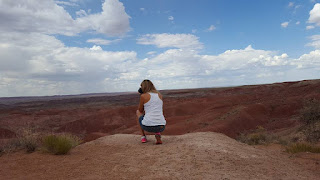
Se arrivaste da est vi imbatterete per primo nel Painted Desert. Siamo a 19 miglia a nord est di Holbrook e davanti a noi c'è un'area di 378 kmq, che comprende una delle più grandi concentrazioni di legno pietrificato (risalente al triassico, tra 205 e 225 milioni di anni fa), siti archeologici con fossili vecchi di oltre 225 milioni di anni e quel Painted Desert, deserto dipinto, che stiamo per visitare.
If you're coming from east you will immediately encounter the Painted Desert, located 19 miles northeast of Holbrook. In front of us there is an area of 378km2, which includes one of the largest concentrations of petrified wood (dating from the Triassic, between 205 and 225 million years ago), an archaeological site with fossils 225 million years old and the painted desert, of course.


Il Painted Desert ricorda lontanamente le Badlands, South Dakota, che visitammo nel 2014 (e che consigliamo!). Una serie di colline che sembrano dipinte da un pittore. I view point più significativi sono Tiponi, Tawa, Kachina, Chinde, Pintado, Nizhoni, Whipple e Lacey Point.
The Painted Desert looks like the Badlands, South Dakota, which we visited in 2014 (and we recommend them!). A series of hills that seem to be painted by a painter: the most significant view points are Tiponi, Tawa, Kachina, Chinde, Pintado, Nizhoni, Whipple and Lacey Point.


Il trail principale tra quelli più semplici è invece il Painted Desert Rim Trail (1 miglio a/r), situato tra Tawa Point e Point Kachina. Il sentiero si snoda lungo il bosco e, oltre ad ammirare i colori del parco, potreste trovare anche parecchia della wildlife che abita il Painted Desert.
The main trail is the Painted Desert Rim Trail (1 mile), located between Tawa Point and Point Kachina. The trail winds through the woods and you may also encounter a lot of wildlife. Obviously the hills are the main attraction.


Once in Arizona, the "in and outside of the highway 40" begins. There are very few towns and even when we follow the original mother road, the road is very bad. It seems that nobody cares about the route 66 along the east part of Arizona. Everything will change starting from Winslow thanks to all the beautiful nature of northern Arizona. We're heading to the first National Park of the trip (Exit 311): the Petrified National Park and Painted Desert, two adjacent parks crossed by the route 66.


Se arrivaste da est vi imbatterete per primo nel Painted Desert. Siamo a 19 miglia a nord est di Holbrook e davanti a noi c'è un'area di 378 kmq, che comprende una delle più grandi concentrazioni di legno pietrificato (risalente al triassico, tra 205 e 225 milioni di anni fa), siti archeologici con fossili vecchi di oltre 225 milioni di anni e quel Painted Desert, deserto dipinto, che stiamo per visitare.
If you're coming from east you will immediately encounter the Painted Desert, located 19 miles northeast of Holbrook. In front of us there is an area of 378km2, which includes one of the largest concentrations of petrified wood (dating from the Triassic, between 205 and 225 million years ago), an archaeological site with fossils 225 million years old and the painted desert, of course.


The Painted Desert looks like the Badlands, South Dakota, which we visited in 2014 (and we recommend them!). A series of hills that seem to be painted by a painter: the most significant view points are Tiponi, Tawa, Kachina, Chinde, Pintado, Nizhoni, Whipple and Lacey Point.


Il trail principale tra quelli più semplici è invece il Painted Desert Rim Trail (1 miglio a/r), situato tra Tawa Point e Point Kachina. Il sentiero si snoda lungo il bosco e, oltre ad ammirare i colori del parco, potreste trovare anche parecchia della wildlife che abita il Painted Desert.
The main trail is the Painted Desert Rim Trail (1 mile), located between Tawa Point and Point Kachina. The trail winds through the woods and you may also encounter a lot of wildlife. Obviously the hills are the main attraction.


Raggiunta un auto degli anni 60 parcheggiata a ridosso della strada significa che state per lasciare il Painted Desert alla volta del Petrified Forest. E' il tributo del parco alla route 66 che scorre proprio ad una cinquantina di metri da dove è posizionata la vettura.
When we finally see an old car parked not far from the road, it means that we're going to leave the Painted Desert and going to the Petrified Forest. This is the tribute to the "mother road" that runs few meters far from the car.

When we finally see an old car parked not far from the road, it means that we're going to leave the Painted Desert and going to the Petrified Forest. This is the tribute to the "mother road" that runs few meters far from the car.

Il primo view point è Puerco Pueblo, un sito archeologico risalente a più di 600 anni fa. Un trail di 0.3 conduce ai resti di una mesa del popolo ancestrale Pueblo.
The first view point we encounter is "Puerco Pueblo", an archaeological site dating back more than 600 years ago. A trail of 0.3 leads to the remains of a mesa of the ancestral Pueblo population.

The first view point we encounter is "Puerco Pueblo", an archaeological site dating back more than 600 years ago. A trail of 0.3 leads to the remains of a mesa of the ancestral Pueblo population.

Proseguendo tra le particolari colline della foresta incontriamo Newspaper Rock, da dove poter ammirare incisioni rupestri sui massi attraverso dei telescopi e, successivamente, Blue Mesa: con un trail di 1 miglio a/r arriverete ad avere i primi contatti con i tronchi pietrificati simbolo del parco.
Driving through this particular forest hills you will encounter the Newspaper Rock, from where you can admire stone carvings on boulders through telescopes and then the Blue Mesa: a trail of 1 mile will give you the first contact with the petrified trunks, the symbol of the park.

Driving through this particular forest hills you will encounter the Newspaper Rock, from where you can admire stone carvings on boulders through telescopes and then the Blue Mesa: a trail of 1 mile will give you the first contact with the petrified trunks, the symbol of the park.


Il tronco più "famoso", diciamo così, è Agata Bridge, particolare perchè adagiato sul letto di un ruscello.
The most famous trunk is called "Agata Bridget". It's very particular, it lies on a river.

The most famous trunk is called "Agata Bridget". It's very particular, it lies on a river.

La zona è particolarmente interessante anche per i cristalli di quarzo. Il Cristal Forest Trail vi condurrà attraverso tronchi con fessure che una volta contenevano cristalli di quarzo chiaro e ametista viola. Purtroppo molti turisti li hanno rimossi e, proprio a causa di questo, è prassi esser fermati una volta usciti dal parco dal ranger che vi chiederà molto gentilmente "se avete prelevato qualche oggetto dal parco".
This area is particularly famous for quartz crystals. The Crystal Forest Trail takes you through tree trunk which once held purple amethyst and quartz clear crystals. Unfortunately many tourists have removed them and, precisely because of this, you could be stopped by rangers who will ask you very kindly "if you have picked up some object from the park."


This area is particularly famous for quartz crystals. The Crystal Forest Trail takes you through tree trunk which once held purple amethyst and quartz clear crystals. Unfortunately many tourists have removed them and, precisely because of this, you could be stopped by rangers who will ask you very kindly "if you have picked up some object from the park."


L'ultimo view point, a ridosso del south gate del Petrified Forest National Park è la famosissima Rainbow Forest. Qui c'è la maggior densità di legno pietrificato ed il trail, brevissimo (0.4 miglia) e facilmente percorribile da tutti.
The last view point, near the south gate of the Petrified Forest National Park, is the very famous Rainbow Forest. Here there is the largest quantity of petrified wood and the very short and easy trail (0.4 miles) can be hiked by everyone.

The last view point, near the south gate of the Petrified Forest National Park, is the very famous Rainbow Forest. Here there is the largest quantity of petrified wood and the very short and easy trail (0.4 miles) can be hiked by everyone.

Lasciato il parco raggiungiamo Holbrook, di nuovo lungo la route 66. Holbrook, se da una parte è la classica "gate town", ovvero la città alle porte di un grande parco nazionale, dall'altra vive ancora il fascino della route 66. Anche e soprattutto grazie al Wigwam Motel, senza dubbio il motel più strano della "66", che troverete uguale anche a San Bernardino, alle porte di Los Angeles, in California, sempre proseguendo lungo la route 66. Il wigwam fu costruito tra gli anni 30 ed il 40.
We just left the park and reached Holbrook, along the Route 66 again. Holbrook is the classic "gate town" because very close to a large national park, but also the memory of the route 66 lives here thanks to the Wigwam Motel, undoubtedly the strangest motel you will find on the mother road. The Wigwam Motels, also known as the "Wigwam Villages", is a motel chain in the United States built during the 1930s and 1940s. They are very distinctive historic landmarks. Two of the three surviving motels are located on historic the other one is located between Rialto and San Bernardino, California.

Le stanze hanno la forma di capanne degli indiani e, posizionate a ridosso di esse, ci sono alcune delle vetture più belle degli anni che furono.
The motel is arranged as a square, with 15 concrete and steel wigwams on three sides and the main office on the fourth; there was also originally a gas station on the complex. The individual units are called "wigwams," not "rooms" or "tepees" or "cabins."

Dopo qualche giorno possiamo davvero finalmente ripristinare il motto "get your kicks on route 66".
After a few days it's finally route 66. It's really "get your kicks on route 66".

HOTEL
Lexington Inn Holbrook (61 euro)
POSITION: **
COMFORT: ***
VALUE: ***
CLEANING: ***
FOLLOW US ON FACEBOOK: WWW.FACEBOOK.COM/DUECUORIPERVIAGGIARE?REF=HL
Nessun commento:
Posta un commento