A very special stretch of California begins just south of Eureka, unknown to many tourists, but that don't mean it's less spectacular. Its name is already intriguing, "lost coast", hundred miles where it doesn't even seem to be ... in California. There are no highways, there are no big cities, there is nothing but an unspoiled nature. Why "lost coast"? It was named the "Lost Coast" after the area experienced depopulation in the 1930s. In addition, the steepness and related geotechnical challenges of the coastal mountains made this stretch of coastline too costly for state highway or county road builders to establish routes through the area, leaving it the most undeveloped and remote portion of the California coast. Without any major highways, communities in the Lost Coast region such as Petrolia, Shelter Cove, and Whitethorn are isolated from the rest of California. The two mayor cities before entering the Lost Coast are Ferndale with its beautiful downtown and Loleta with the very famous Loleta Cheese Factory. They really are the "gateway to the lost coast", crossed by a single road (Mattole rd) which makes a kind of semicircle that further south rejoins the "101".

(Avenue of the Giants)
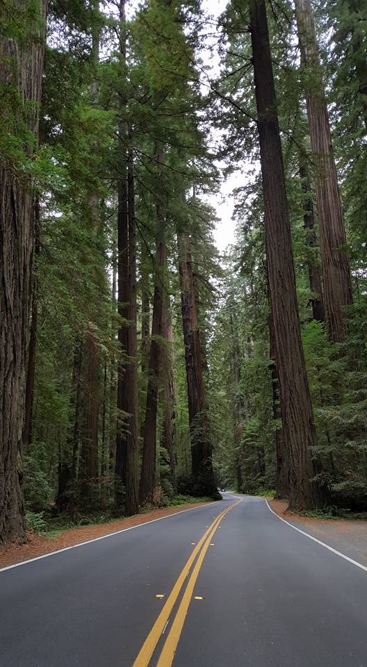
Percorrerla è un'esperienza affascinante ma dovrete avere a disposizione almeno tre ore, quelle che invece non abbiamo avuto noi durante la tappa Arcata-Petaluma, la più lunga della spedizione con i suoi oltre 500 km e oltre 6 ore spese in auto. Non possiamo però mancare un altro grande appuntamento con i redwoods lungo gli ultimi tratti di "101" che da Astoria, in Oregon, di fatto, non abbiamo più abbandonato. Ancora una volta il nome la dice già lunga, "Avenue of the Giants", la strada dei giganti, che da Elinor a Philipsville rende magico l'Humboldt Redwoods State Park (ingresso gratuito).
Going through it is a fascinating experience but you must have at least three hours to drive the entire road. Unfortunately we didn't have enough time during the Arcata-Petaluma stage, the longest of the on the road with its over 500 km and over 6 hours spent along the road. But we can not miss another big appointment with the redwoods along the last sections of "101" that from Astoria, in Oregon, we have actually never left anymore. Once again the name says everything: "Avenue of the Giants", which from Elumbor to Philipsville makes the Humboldt Redwoods State Park (free admission) a very special place.
(Avenue of the Giants)
La Avenue of the Giants non è nient'altro che una deviazione dalla strada madre, la 101, un percorso tra i più suggestivi dell'intera California tra maestose sequoie giganti. Potrete osservarle anche soltanto aprendo il finestrino della vostra auto lungo i 52 km della "Avenue of the Giants", oppure fermandosi ogni qualvolta lo scenario vi impressionerà.
This world-famous scenic drive is a 31-mile portion of old Highway 101, which parallels Freeway 101 with its 51,222 acres of redwood groves. It is by far the most outstanding display of these giant trees in the entire 500 mile redwood belt and is accessible to all with convenient services provided along the way. The Avenue of the Giants is surrounded by Humboldt Redwoods State Park which has the largest remaining stand of virgin redwoods in the world.

Tra voi ed il cielo ci saranno sempre questi enormi redwoods, di un verde così intenso da sembrare un quadro appena dipinto dal migliore dei pittori. E non mancano i trail, tra i più suggestivi dell'intero nord della California. Il principale è l'interminabile Bill Creek Loop, lungo addirittura 112 km, che si addentra all'interno della foresta.
Between you and the sky there will always be these huge redwoods, made by a green that seems to be just painted by the best painter. And do not miss the trails, among the most evocative of the entire northern California. The main one is the endless Bill Creek Loop, 112 km long, which goes into the forest.

Noi abbiamo percorso il Founders Grove Trail (0.6 miglia - loop trail), che troverete (arrivando da nord), poco dopo aver intrapreso il cammino lungo la Avenue of the Giants. Svoltate a sinistra in Dyerville Loop, troverete il parcheggio del trail pochissimi metri dopo sulla sinistra.
We hiked the Founders Grove Trail (0.6 miles - loop trail). Drive 1/4 mile on Avenue of the Giants, and make the next left onto Dyerville Loop Road. The trailhead parking is a few hundred feet ahead on the left.

L'altro percorso da non perdere è il Rockfeller Loop Trail (1.1 miglia - loop trail), situato proprio lungo la Mattole Road di cui abbiamo parlato sopra. Il riferimento sarà il visitor center del parco: troverete la Mattole Road proprio 4 miglia a nord di esso e dovrete svoltare verso ovest e proseguire per 1.5 miglia prima di trovare il parcheggio del relativo trail.
The other trail you shouldn't miss is the Rockfeller Loop Trail (1.1 miles - loop trail). If you are coming from the Avenue of the Giants: four miles north of the park visitor center and just south of the hamlet of Redcrest, turn west on Mattole Road (mile marker 20.6) and drive 1.5 miles to the parking area for the Rockefeller Forest Loop Trail. Park headquarters and the Visitor Center are located on the Avenue of the Giants, State Route 254, between the towns of Weott and Myers Flat

Se voleste provare l'esperienza di guidare attraverso un albero avrete ancora due possibilità, la prima al Humboldt Redwoods State Park and the Shrine Drive-Thru Tree (8 dollari - Avenue of the Giants, Weott), l'altra poco dopo aver lasciato il parco in direzione sud, al Chandelier Drive-Through Tree (5 dollari - 67402 Drive Thru Tree Road, Leggett). A controllare che stiate rispettando le regole c'è sempre lui, big foot...
If you want to try the experience of driving through a tree there are still two options left, the first one is stopping by the Humboldt Redwoods State Park and the Shrine Drive-Thru Tree ($ 8 - Avenue of the Giants, Weott), the other one shortly after leaving park south, by the Chandelier Drive-Through Tree ($ 5 - 67402 Drive Thru Tree Road, Leggett). And don't forget that's still the land of Big Foot...

Noi invece, non smettendo mai di... non crescere, restiamo ammaliati dalla più classica delle "americanate" che, nonostante tutto, continuano a piacerci tremendamente. Il suo nome è Confusion Hill (75001 N Highway 101, Piercy, CA 95587-8805), le cui attrazioni principali sono un trenino panoramico e soprattutto la Gravity House, la casa della gravità (10 dollari il trenino, 5 la Gravity House).
But we never stop ... not growing up. This is why we are bewitched by a very weird place. Its name is Confusion Hill (75001 N Highway 101, Piercy, CA 95587-8805), whose main attractions are a scenic train and above all the Gravity House.($ 10 - the train, $5- the Gravity House).

(Confusion Hill's Seven Favorite Theories)
Un percorso brevissimo vi porterà all'interno di una casa e nei suoi dintorni in cui la gravità... è decisamente confusa. Come del resto lo sarete voi. Fatto sta che combatterete una battaglia (persa) con la gravità stessa, sfidando le leggi della natura.
The attraction, which opened in 1949, includes what is dubbed as a "gravity house," a structure built to give the interior visitors tilt-induced optical illusions, similar to the perspective on a gravity hill. Occupants experience the need to stand upright when they actually already are.

Difficile stabilire se sia tutto uno stranissimo effetto ottico o se davvero sia un luogo del tutto particolare, ma di sicuro è molto divertente. Ideale se con voi viaggiano dei bambini. O se come noi non siete cresciuti abbastanza per evitare di fermarvi...
It's not easy to determine whether it is all a very strange optical effect or if it really is a very special place, but for sure it is very funny. The perfect place if you are traveling with children. Or if like us you have not old enough to avoid stopping...
It's not easy to determine whether it is all a very strange optical effect or if it really is a very special place, but for sure it is very funny. The perfect place if you are traveling with children. Or if like us you have not old enough to avoid stopping...

Once in Leggett we say goodbye to the "101" after a few days (If traveled entirely, would lead us directly to San Francisco) and approach six years after the first time one of the three most famous scenic byways of the entire United States, the legendary highway 1 that, from here to Los Angeles, will follow the trend of the Pacific Ocean for 1055 kilometers.

Il primo tratto di "1", che sino a Flumeville è conosciuto anche come "shoreline highway", non è particolarmente adatto ad un post pranzo. E' una serie interminabile di curve sino a Rockport dove, finalmente, la musica cambia. Il "big sur", il tratto che da San Francisco collega Los Angeles, resta nella mente del turista il più affascinante della Highway 1, ma dopo aver percorso quello a nord di San Francisco molto probabilmente cambierete idea.
The first section of the "1", which up to Flumeville is also known as "shoreline highway", is not particularly suitable for a post lunch. It is an interminable series of curves up to Rockport where, finally everythin changes. The "big sur", the stretch that connects San Francisco to Los Angeles, remains in the tourist's minds the most fascinating of the entire Highway 1, but after traveling the stretch north of San Francisco you will most likely change your mind.


La nebbiolina ci accompagna sino a Mendocino, indiscutibilmente il fiore all'occhiello della costa a nord di San Francisco. Poco prima di entrare in città incrocerete Point Cabrillo Light Station, un vecchio faro del 1909 situato all'interno del Point Cabrillo Historic State Park (5 dollari), ma è per il suo downtown che Mendocino è diventata famosa nel mondo.
The mist accompanies us till Mendocino, indisputably the flagship of the coast north of San Francisco. Shortly before entering the city you will cross Point Cabrillo Light Station, an old lighthouse (1909) located inside Point Cabrillo Historic State Park (5 dollars). Anyway, Mendocino is mostly famous for its downtown...

Mendocino è la più classica delle città fiabesche lungo la costa selvaggia della Northern California, ubicata su un promontorio scavato dalle onde e circondato da una parte da una natura che definire incontaminata è quasi riduttivo, e dall'altra dall'oceano pacifico. Furono i coloni provenienti dal New England a costruirla nel 1850 ad immagine e somiglianza di una tipica cittadina costiera del nord-est degli Stati Uniti, ed ebbe un primo momento di notorietà grazie al traffico di navi che trasportavano legname ricavato dal taglio delle sequoie.
Mendocino is the classic fairy-tale town along the wild Northern California coast, located on a promontory dug by the waves and surrounded by a prestine nature and by the Pacific Ocean. The settlers coming from New England built Mendocino (1850) like a typical coastal town of the north-east of the United States. It had a first moment of fame thanks to the traffic of ships transporting lumber obtained from the cutting of the redwoods.

Tuttavia le segherie chiusero intorno agli anni '30 e, dopo qualche anno di difficoltà, furono gli artisti a riportarla in auge, grazie anche al film del 1955 la Valle dell'Eden con James Dean, ambientato proprio a Mendocino. No. Mendocino non è una città come le altre. Qui non troverete le grandi catene e le più importanti aziende americane e mondiali. Qui è tutto "local", tanto che uno dei soprannomi della cittadina è "spendocino" per via dell'elevata qualità dei prodotti che troverete nei negozietti lungo le vie di downtown.
However, saw mills closed around the 1930s and, after a few years of misery, many artists brought Mendocino back to life, thanks also to the 1955 movie East of Eden with James Dean that was set right in Mendocino. No, that's not a city like any other. Here you will not find famous brands and the most important American and global companies. Everything here is "local" and you'll immediately recognize the high quality of the products offered by the many shops along the streets of downtown.

Nonostante i suoi 1000 residenti e le ridotte dimensioni, Mendocino richiama inoltre moltissimi artisti che ritroverete intenti a fotografare o dipingere lungo le strade. Ne abbiamo trovati diversi (e consigliamo il video alla conclusione del post) intenti a dipingere una città che, grazie anche alle sue case vittoriane tipiche del New England, è un piacere per gli occhi.
Despite its 1000 residents and its small size, Mendocino also draws many artists: you will meet them while photographing or painting along the streets. We found several of them painting a city that, thanks to its Victorian houses, is really charming.

(colonial house - Mendocino)
Cosa vedere a Mendocino? L'attrazione principale è sicuramente la Blair House (45110 Little Lake St), la casa de "la Signora in Giallo". Nel telefilm la signora Fletcher era di Cabot Cove, una ridente cittadina del New England. Abbiamo incontrato il giardiniere che ci ha raccontato alcune storie interessanti sulla casa che, di proprietà di un ricco avvocato di San Francisco, è stata per anni un bed and breakfast.
What to see in Mendocino? The main attraction is definitely the Blair House (45110 Little Lake St), the house of "Murder, she wrote". In the show, Mrs. Fletcher was from Cabot Cove, a charming New England town. We met the house gardener who told us some interesting stories about the house that, owned by a rich San Francisco's lawyer, has been a bed and breakfast for years.


(Blair House)
A Mendocino, che si visita rigorosamente a piedi, potrete inoltre visitare (da fuori) il piccolo Kwan Tai Temple, il tempio fondato nel 1852 che espone l'altare dedicato al dio cinese della guerra. (45160 Albion St)
In Mendocino you can also visit (from outside) the small Kwan Tai Temple, the temple founded in 1852 that shows the altar dedicated to the Chinese god of war (45160 Albion St). You don't need to use your car, everything is located around downtown.

Nonostante la "101" permetta di raggiungere Petaluma molto più velocemente, non ce la sentiamo (e, ne siamo sicuri, succederà lo stesso anche a voi) di lasciare la "1" che, con il passare delle miglia, diventa sempre più affascinante. In questo particolare tratto sono presenti diversi luoghi da non perdere lungo la highway 1, ma non riusciamo a fare a meno di fermarci ad ogni singolo view point, complice un cielo che finalmente si è aperto e che ci regala un panorama incantevole.
Despite the "101" allows you to reach Petaluma much faster, we really don't want to leave the "1" and it will probably happens to you. This road gets more and more fascinating and there are several places not to be missed. Be sure to have time, because you'll be forced to stop at every view point and take some pictures. Those are really enchanting views.

Nel caso aveste più tempo a disposizione rispetto a noi ecco i quattro luoghi imperdibili del tratto di highway 1 che va da San Francisco a Jenner:
- Bowling Ball Beach Beach, una stranissima spiaggia formata da rocce che sembrano... palle da bowling.
- Point Arena Lighthouse, il punto in assoluto più vicino alle Hawaii dell'intera "mainland" degli Stati Uniti. Il faro situato al suo interno raggiunge i 35 metri di altezza.
In case you have more time to spend in this area, these are the four must-see places on the stretch of highway 1 that goes from San Francisco to Jenner:
- Bowling Ball Beach Beach, a very strange beach formed by rocks that look like bowling balls.
- Point Arena Lighthouse: the absolute closest point to Hawaii of the entire mainland of the United States. The lighthouse located inside the Point Arena is 35 meters high.


(California Highway 1)
- Salt Point State Park, 9 km2 di vertiginose falesie in arenaria che si gettano nel mare. Il parco è tagliato in due dalla Faglia di Sant'Andrea, da ciò ne consegue che le rocce che troverete nel versante orientale siano completamente diverse da quelle del versante occidentale. La prima entrata del parco (quella più a nord), porta ad approcciare alcuni trail, ma è quella più a sud la più "famosa" e turistica. Qui troverete anche il visitor center (Grestle Cove).
- Fort Ross State Historic Park, legato ai tempi dell'esplorazione da parte della Russia zarista della costa californiana ed al selvaggio West prima dell’epopea dei pionieri americani. Oggi è un luogo pacifico e pittoresco in cui si respira la suggestiva atmosfera del passato.
- Salt Point State Park covers 6,000 acres (2,400 ha) on the coast of Northern California, with 20 miles (32 km) of hiking trails and over 6 miles (9.7 km) of a rough rocky coast line including Salt Point which protrudes into the Pacific Ocean. The park also features the first underwater preserves in California. The constant impact of the waves forms the rocks into many different shapes. These rocks continue underwater providing a wide variety of habitats for marine organisms. The rocks of Salt Point are sedimentary sandstone. Due to the large amounts of sandstone, small cave-like features called tafoni can be found along the shore of Salt Point.
- Fort Ross State Historic Park is a former Russian fur trading outpost of Fort Ross plus the adjacent coastline and native coast redwood forests extending inland. Fort Ross, active from 1812 to 1842, was the southernmost settlement in the Russian colonization of the Americas. It was founded by the Russian-American Company in 1812. Most of the Fort's buildings are reproductions. The one original structure remaining from the Russian settlement, the commander's house, is a National Historic Landmark and on the National Register of Historic Places. Today it is a peaceful and picturesque place where you can breathe the evocative atmosphere of the past.


(California highway 1)
POSITION: ***
COMFORT: ***
VALUE: ****
CLEANING: ****
FOLLOW US ON YOUTUBE
Mendocino e la Highway 1
FOLLOW US ON FACEBOOK:
WWW.FACEBOOK.COM/DUECUORIPERVIAGGIARE?REF=HL
Nessun commento:
Posta un commento